Categories
Uncategorized

The Current Security Situation in the Sierra Nevada De Santa Marta

This might be the most relevant and important entry to this Blog, and the one I worked the hardest to be able to write (although I suffered the most for the entry on Pico’s, that’s for sure!). The following will scare the shit out of you, and then you might be surprised at my conclusion that perhaps for the first time since the 80’s, the Sierra is Climb-able.. this is a news flash potentially worthy of National News in Colombia.. the problem is, or the good part is, that I might be the only person not in the Military who has put this piece of info together, and the Military isn’t in the business of climbing mountains recreationally. My conclusions are derived from personal exploration and a series of conversations with sources within the Brigada (Brigade, which in Colombia can be as many as 10 Batallions, and they currently have defined geographic areas of Operations that I think cover the whole country, but tend to put their units on road blocks and in little fire bases close to Guerilla wildernesses with their headquarters usually in the biggest town around where they have a garrison that locals call ‘El Battalion’)responsible for about 2/3 of the Sierra, with the last third being the western side that has been pacified the longest, which is headquartered I believe in Fundacion on the west side of the Sierra.
The Theme Song for this Entry is One Night in Bangkok, that cheesy 80’s song from the play Chess, because, in Colombia ‘You can feel the Devil walking next to you’… The sad difference between Colombia and Bangkok is that in Asia, the Devil knows he is the Devil and plays his part amiably, and with humor, but in irony deprived Latin America (Mexico and Argentina notably excepted), the devil is either so cunning or so convinced of his own righteousness that he has forgotten or never knew he was the Devil.
If you ask a Colombian Policeman, as I apt to do on occasion, donde estan el FARC-EP!? (where are the Revolutionary Army of Colombia Peoples Army !?) they will give you the standard answer first: Todos Luageres ( Everywhere!) but then, if they feel like being helpful, which is usually, they will either point a finger in the direction of a neighborhood, or tell you “pero no preocupes, es seguro aqui”.. (but don’t worry, it’s safe here… ). For whatever ways in which traveling is somewhat easy in Colombia, pretty low stress, this is a habit of asking this question I have developed that has in fact influenced my itinerary more than once. War has been a fact of life in this country since it’s establishment now 197 years ago (although the revolution began 202 years ago, it almost feels like it never ended, and in a way it didn’t, because the divisions between Santander and Bolivar were the dynamic until the 80’s, when cocaine came along and just added a new even less idealistic player).
For some background, there are 5 human elements to worry about in Colombia. To keep things simple, I am not going to blur the distinctions between these 5 groups, although trust me, things are blurry!:
The FARC
The ELN
Right Wing Paramilitaries
Narco-Trafickers
Petty Criminals

The Military have emerged as the good guys, after again, a blurry past of corruption, then overzealous pursuit of their goals, to include massacres and rampant collusion with the Paramilitaries, and two scandals now entering history, both around 2006, of a commando unit killing for narcos, and another where they killed civilians, perhaps accidentally, then re-dressed them up as FARC to avoid prosecution. But when I see a colombian soldier today I see a friend. I see Operation Jaque and just good people tired of pretending that Colombia will get a better state from Revolution. They have emerged as a professional military in the way that the British Army did in Northern Ireland, kind of a tough extension of the Police, with some protocol skills to boot.
The National Police Force is largely friendly, professional, and what you would want police to be on the street level. I fear cops in the US way more than I ever feared any cops I met in Colombia. They are usually young, friendly, good at giving directions, and are shifted between locations nationwide about once a year to avoid corruption, and again, usually have good people skills. They have a kind of city side with guys sporting pistols, and a kind of almost army side you see in some of the tougher locations.. they can be distinguished from the army by their plain green BDU’s as opposed to the pixellated camouflage of the Army and slightly different ones of the Marines (Naval Infantry). Corruption may exist, but again, when you meet them on the street it has been for me 98% a good experience. The Nationalization was a reform by Uribe and apparently successful, and maybe a good step for Mexico as well.
The famed M-19 no longer exists, they demilitarized years ago after some funny acts like stealing Simon Bolivar’s sword and some not so funny acts like taking the Supreme Court at the behest of Pablo Escobar to stop extradition to the US of Drug lords, with a loss of over 100 lives. The current Mayor of Bogota is a former M-19 member, to show how much they are in the past like a kind of Colombian Weathermen Underground.
So making this relevant to the Sierra, let me remove a few more groups from the Pan-Colombian equation. The ELN’s power base is around Norte De Santander, a department maybe 100 miles south of the Sierra, in the Cordillerra Oriental along the Venezuelan border, and, surprise, surprise, a good area to grow Coca.. it’s a funny theme in Colombia that the People’s Revolution is usually deemed most ripe for success in places that for some strange reason happen to be the mid mountain slopes that make for good coca.. if I wasn’t trying to focus on the sierra, I could expound on this theme quite a bit. Back to the ELN, their Low Thousands if not less strong revolution, a kind of ‘me too’ kid brother to the FARC, is kind of too far away to be of worry in the Sierra.. they have distinct turfs, have battled between each other before, but they have bigger problems and better revenue sources these days than to bother each other.. the ELN has recently made headlines by trying to join the ongoing peace process in Havana, and also returning some recent kidnappers as a sign of good will, although not the two german guys that wandered into Norte De Santander on their Truck trip through South America, but I promised this would conclude in good news!
The Paramilitaries, whom I could smell the stink of all over Valledupar, like if the football players in your high school started picking up guns and killing everyone who made trouble in the halls.. part of you didn’t mind seeing the bully, the FARC, get his, but they often would kill his mom and his girlfriend as well.. it got very ugly… and as I might have mentioned it got very ugly in the Sierra as well. Between Guatepuri and El Atanquez, a battle raged in 2002 that killed 200 people, everything from combat to executions on suspicion of collaboration was to blame.. not to freak you out more, but there were even killings of suspected FARC prostitutes with cans of Bug Spray by the Paramilitaries, not that this is a good way to make the sierra seem attractive, but it was rough for years in Valledupar, which as a cattle ranching town, the home of the Cattleman’s music, Vallenato, kind of a Colombian Austin or Bakersfield musically, was ripe for Paramilitary formation and action. They demobilized in 2006 under an amnesty that tried to wrestle the war back into the hands of the military after it almost went off the skids in the previous 4 years, most notably in somewhat distant Cordoba and Antioquia, although the famed leader of the AUC there had no doubt influence on events in both the Sierra Nevada and La Guajira, Carlos Castano and his two brothers, Vincinte and Fidel, now being immortalized in the somewhat intelligent Caracol Network miniseries Los Tres Caines, the Three Caines. Like Future President Uribe, also from Antioquia, their father, Jesus, had been kidnapped by the FARC and they vowed a revenge that became a national movement. But the paramilitaries are no longer any issue in the Sierra. They are an issue in smuggling in parts of the country, as kind of re-hashed gangs like something out of a bad mercenary movie, and in places where land reform is occurring (one famous group in this instance is called the Black Eagles)..all these areas are in the North of Colombia, but it’s a big country, so nowhere close to the Sierra, thankfully.. all-righty.. so who is left on our rogues list.. ah..
Narcotraficantes.. well, drugs do in fact leave from the Caribbean coast of Colombia still, although I don’t think in the same volume as the Pacific coast and Mexico bound, as Mexico, mostly the Zetas and Sinaloa Cartels, have taken over world distribution, a bit like DeBeers, turning Colombia, Peru, and Bolivia into somewhat decentralized resource suppliers after their previous heydays (first Peru before anyone even knew it was a problem in the 50’s, then Bolivia and Colombia in the 80;s through the rise of Mexico in the last decade or so… Mexico’s Banana Republic’s..oh how the world turns!) These guys work quite silently, but a big group in La Guajira was busted recently, all at a beach party of all things! The Local Gangs shut down Santa Marta on New Years of 2011 as a sign of respect.. no one could party without being killed that year, in kind of the Waikiki of Colombia.. so they are still strong, but they want nothing to do with the high sierra nor climbers nor indigenous would be my guess. the Busted Group seems to have been the newest incarnation of the North Coast Cartel. The production of Coca paste is kind of decentralized, so although the FARC, ELN, or Paramilitaries will control these areas, these guys just buy raw material like any middle man. The big names now in Colombia are Los Rastrejos, and Los Urubanos. They are the heirs of the Cali Cartel. Something called La Officina de Envigado seems to be on the decline, which is the heir of the Medellin Cartel.

http://en.wikipedia.org/wiki/Los_Rastrojos
In the Hay-Days of the FARC, from 1998 when the FARC went on the offensive but before the election of Uribe in 2002, the 19th front which controlled the Sierra Nevada numbered 800… today: One Squad of about 15 operates in the eastern Sierra in coco growing areas fairly well clear of any areas you might access to climb the mountain.The closest being Guatepuri, and the two valley’s option, but likely still a two day hike for them if not more. I don’t know if they consider themselves the remnants of the 19th front, or are the 59th front I will mention later. I was told by the military that around Guatapuri east you might see 2 or 3 of them at a time, occasionally, but they are merely looking, snooping and pooping as it’s called in the US Army. Guatapuri, with it’s platoon, also feels safe I was told, there has been no FARC action anywhere in the area since 2009. Above Guatapuri, a few people did warn me that in the prior months they had seen the FARC come through, that it was a semi regular occurance, but I had not received the previous information to whittle down whether they come through in force or just to say hi. The Colombian Army actually has pictures of about a 3rd of them on the wall, like yearbook shots.I recently met a Nun in the Anthropology Museum of the Hermanas de Laura (The Sisters of Laura, Laura being a beatified Colombian nun who’s work began with the Embrerra in Choco and western Antioquia about a hundred years ago, and her order spread to looking after and converting natives all over colombia and now other countries) on the west side of Medellin, and I asked her where she had lived.. after a long list she mentioned the Sierra, and I believe their Convent was over in the area I am describing, the mountains above Riohacha. She said that they once threw her off a donkey, but no harm came to her. This is somewhat inconclusive, but the military found it incomprehensible that the FARC would mess with anyone in the Sierra these days.
When the FARC wanted to take over the whole country, the Sierra was a piece of a larger puzzle of taking over all of Colombia. They also see themselves as defenders of the Indigenous, who tolerated and even occasionally assisted them. These days the Sierra has relevance as a short cut from Venezuela to Santa Marta for the dwindling FARC urban presence, perhaps as a trafficking route, but this is the conventional wisdom twice voiced to me why any Guerrillas would be up there..other than protecting so Coca bushes in the east of the range. It is this question that creates the what if? What if two or three did happen by… what if 10 go by headed to Santa Marta?
Who else might be trekking through is the group on the Venezuelan Border. It is now documented fact from a successful cross border operation into Ecuador a few years back that Hugo Chavez for years aided the FARC and even gave them 300 Million USD at one point. There is another group of FARC living on the other side of the Valley in the Sierra Oriental, the Eastern Mountain Range of both the Andes and Colombia. It’s kind of neat that you drive from Maicao and watch the Andes bein as little hills to your left, and by Valledupar there is a 12,000 foot mountain, Painted Mountain, to your left, within maybe 3 hours of the first hill, but that prettiness, like usual in Colombia, comes at a price of them being a bit.. well.. dodgy, 150 strong FARC 59th Front Dodgy.. and mildly active… again, they seem to just be guarding Coca production and smuggling routes (into Venezuela to go to Cuba or elsewhere in the Caribbean, or out of Colombia via the coast to go to Mexico I am speculating). These guys live up there and go hang in Venezuela when Uncle Hugo likes to have a Bar B Q for them to forget his cancer troubles, and they have committed a few attacks, but against specific targets. It was documented that in 2011 they tried to mess with the rails of the coal train, and they killed a policeman. I don’t know what if anything happened in 2012, although I heard of nothing my first month in Colombia, I hadn’t quite acquired the ear for it yet, still figuring out what was good to eat and where to go. In the 3 months I have been here, to signal the end of the ceasefire they had called for the Havana Negotiations that have been ongoing for a few months, right on a road I had come down weeks earlier, near the junction between the roads to Uruba, Maicao, Riohacha and Valledupar, about 3 miles east of Maicao, they ambushed and killed three policemen, which was national news along with a string of other attacks that all happened to signal that cease fire termination, which was a bit of a negotiating tactic. The few hostages taken that day in other parts of the country, mostly the south west,were released within a week or two as a result of the negotiations. The FARC has, by the way, claimed they are no longer interested in taking hostages, kidnapping as you might call it, in a move that might be seen as a plea for legitimacy to go with these negotiations and a growing feeling of malaise in the country after 50 years of the crap I am writing about.
So the last is petty criminals.. I felt pretty safe with about everyone I met once I was into the Sierra.. there was the Dignity of mountain people.. the Kogui will get drunk and hit you up for cash, claiming it’s for their sick kid, but it’s for a Club Colombia, but I never saw any evidence of crime internally or between the tribes, even though there is a spirited rivalry and distrust between some of them, and of the Mestizos. The Arawaku’s came across as too dignified for such activities, although I once left some gear by a river, and it disappeared, and as I had thought, a few kids had taken it. I found a Mamo, a kind of chief figure, who was a nice measured wise old guy, and he appreciated what likely had happened as I did, asked around and came back with it, although I had to pay a kind of 2 dollar fee which I think they put towards cell phone minutes, but it earned me an offer to stay in their house that night for free, which I took up both out of good nature and curiosity. I didn’t get much of a read on the Wiwa’s although they came across as more patient Kogui’s. The Kancuamos that are basically mestizos now seemed pleasant enough, they party a bit like other modern Colombians but I saw no special tendencies towards delinquency. And no one lives above 7500 ft.. I could see some of the natives being fascinated by modern camping gear and climbing gear, but I doubt you would see them by chance by the time you got the the base camp. I have a friend who wandered up into the sierra two years ago above Nabusimake, and he told me of being quite impacted by Altitude and Malnutrition which was more a condition of his life and inexperience than anything occurring in the Sierra, but a Kogui happened along and insisted he mount his donkey, nursed him for a bit and helped him down the mountain.

video that shows what the sierra was like maybe 10 years ago:

Video on hostage taking nar Santa Marta, but it appears tobe just a criminal thing:

PResident Santos visits an indigenous village in the Sierra, and the Governor’s of all three adjoining states are interviewed.

A police video about taking some doctors to a village to work with the Wiwa’s, someplace on the Santa Marta Side, likely above Minca..

recent attack on 3 cops on read to Maicao:
Categories
Uncategorized

A Unique Geography

What makes the Sierra Nevada de santa Marta most unusual is that the summit of such a large mountain is so close to the sea, and the Caribbean at that, not usually considered to be a deep sea, unlike it’s nearby biiiiiger brother, the Pacific, whose ring of fire is famous for tectonic activity that has created a ring of uniformly tall mountains, ranging from 12,000 ft.-ish (4000 m) mountains in places like the American West and Canada, Japan, and even New Zealand, Hawaii, and Indonesia to ranges that peak taller like the Alaska Range and the Andes.
The Andes are considered the second tallest mountain range in the world, but dropping from there, only the Alaska range, the nearby Wrangell-St Elias Range and the Caucasus’ reach such heights as this above sea level as Pico Cristobal Colon (you do kick ass, Mauna Loa, at like 35000 ft all told, but half of you is hiding under the Pacific..), so if we go with the maximum height of each range, and consider the Sierra Nevada de Santa Marta to be a separate range from the Andes, which it is as far as I can tell geologically, despite proximity (I gotta read about tectonics now!?.. it’s like having a girlfriend that get’s angry at you don’t know her first pet’s name..), then by my rough math, it’s the 5th highest range in the world… wait, it might be taller than Mt. Elbrus, in the Caucus’…
holy crap it is, by 200 ft or so.. there we have it… it’s the 5th tallest range in the world by highest peak above sea level, since I forgot the Alaska Range (which is a bit absurd if you knew where I kind of live, but it’s funny how I start to take the old girl for granted, forgetting how special she really is) after:
The Himalayas, with Everest at above 29,000 ft.
The Andes with Aconcagua at 23,000
The Alaska Range with Denali at 20,000
The Wrangell-St Elias Range, with Mt. Logan at 19,000
Colon, like I have said, is 18,701, although I also see it listed on Wikipedia as 18,947..

Honorable mention goes to Popocapatel, smoking all the time, and Orizaba, the highest peak in Mexico but both slightly shorter than Colon, although both of which might be visible from the Gulf of Mexico coast. But they are also both well inland. The mountain of my visual dreams, Mt. St Elias, next to Logan, and also quite close to the Gulf of Alaska in the North Pacific Ocean.. it’s a stunning mountain, white from toe to cap with snow, and to see it on a clear day from the gulf or Yakitat or an airplane is a spiritual experience.. it get’s climbed once every three years or so by an intrepid few, but returns me to the Sierra, since the two share this odd distinction of being so tall and so close to Salt Water, but it might be a good 5 miles further from the coast, 30 miles to Colon’s 25, although from the sea it looks like it’s only 2 miles from shore. I am definitely revealing a bias towards St. Elias.
Anyhow, the Caribbean, if I know it well, bottoms out at like 12,000 ft, not terribly deep, but not shallow either.. again, the Pacific goes to like 30,000 ft down… and of course James Cameron has been there..
So facet number 2, the seaside location, is another point for the sierra, because who the heck would guess that anything that tall could be so close to the Caribbean. I have traveled extensively the sea’s edges, and all through the US, and mostly Pacific Coast of Latin America, and it is marked by it’s flatness in the US and Central America, mangroves and unsettled areas like the mosquito coast of Honduras, with mountains kind of close as aforementioned but hardly hovering over it in Mexico. But then you get to Colombia, and flat flat flat going counterclockwise, and then Boom, where the hell did this come from!? It’s descends into the Sea from Cienega to Palomino more or less, all around Santa Marta, like the north side of Maui (yes it really does take 2 hours to drive to Hana, even though it looks like it’s right there!). Palomino offers kind of the first ocean plane, about a mile wide at the town, which widens by the time you get to Riohacha south of which the Sierra is petering out into (dangerous) hills, ending by Maicao.
So to harp on this, imagine starting at the sea, and weaving up through jungle river canyons, then encountering people living as high as 7500 ft who are dependent upon sea shells for their biggest fix (more about the habits of the Indigenous of the Sierra in other posts, but that weird gourd thing you see them rubbing with a stick all the time, it’s made of boiled sea shells…then still being within sight of the sea, at about 8 degrees north of the equator, and encountering snow and then a glacier.. there might be this kind of proximity in Ecuador, or down in Patagonia, but I am not sure that such an abrupt juxtaposition of all the climactic zones exists anywhere else on earth.. maybe Hawaii, but I am afraid to look, but wait, sure, Mauna Loa is likely as close to the ocean, and at a similar latitude.. maybe 10 or 12 north, but it’s 4000 ft lower…
and then the odd fact that this range is so small… you could drive in a circle around it in a day, and likely not break 2000 ft… it’s literally a pyramid by the sea.. and unlike anything else in the Caribbean. Now throw in a dry side and a wet side, and the truly old school indigenous groups, and you have something unique.. 30 something major rivers running down from it, in every direction creating countless valleys, the most lush and interesting to me in the north and west sides, where the culture and biodiversity likely abounds.
In Colombia, let alone the sierra, I have seen a new bird species just about every day, something markedly different each time.. I am dazzled by it, and I remember decompressing in a little resort in Pueblo Bello, on the south side of the Sierra, sunbathing by a pool that cows also drink out of (moderate your vision of luxury for northern colombia, they were also drying coffee on the cement near the pool, and there was a squad of soldiers camped out in a nearby shack.. I also let a mule into the nearby field by accident and had to chase him out with a teenager who worked there, past the pool..), and trying to distinguish the different bird calls I was hearing led me to see about 8 different species… I was a bit stunned, because I can’t imagine many back yards in the US that could offer more than 4 or 5 at any one time…
Throw in the variety of human experiences occurring on the slopes of the mountains.. Soldiers fighting the last vestiges of a guerilla war, with guerillas snooping about in it’s eastern extremes.. an almost modern city tucked between it’s ridges by the sea, with a port alive with commerce and likely some of it illicit, ranchers and victims of the paramilitaries licking their wounds in Valledupar while a corrupt little government goes about it’s business, and there occur the daily events of a social club that birthed one of the most important music genre’s in Colombia, Vallenato, which was originally the musical storytelling of ranchers until some oligarchs, including a former Colombian President I believe, got ahold of it and started to record it in the ’60’s after paying these guys to sing for them for a bit. Then of course the mestizo coffee growers, and the possible coca growing on the east flanks, a smattering of cattle ranchers, but then of course the three remaining old school indigenous groups living up in the hills, calmly awaiting the time when history proves their method of living correct over ours, acting as if the fools with all the metal contraptions in the valleys will someday figure it out, pensively chewing their coca and seashells and admiring the view.
I wish I could say that there was a bunch of scuba diving all around the Sierra, but it’s mostly in Tayrona park, since the rivers there don’t pump out the amount of mud they seem to on the western and north-eastern shores of the Sierra, but yes, there are tropical reefs and glaciers within I would guess maybe 35 miles of each other.. would have to play with google maps for a good answer… there you have it, tall, small in footprint, and towering over the odd ball laconic majesty that is the Caribbean Sea..not a place anyone associates with mountains, outside of a few volcanos and a few nice hills in Jamaica, all right, they are mountains..

Categories
Uncategorized

The Bane of the Sierra: Picos (Bug Bites), Infections, and Diseases

It’s the jungle.. There are some bad diseases about.. But in fact, the jungle ain’t the worst of it.. It’s the disturbed areas, where there is ranching and forest and food web fracturization that the bad shit really lives in…human contact is usually necessary for human diseases.. How do I know this.. because I am sitting in an emergency room right now, likely being diagnosed with leishmaniasis, in Medellin…it’s better than Chagas which was my first fear.. I don’t have swollen organs other than perhaps my colon, which in Latin American can come from any number of things, ask ol Montezuma.

So now writing from Cali, a few weeks later, I will fill in the distillation of my understanding of the disease threats in the Sierra Nevada de Santa Marta. this might be a bit horrifying, but there are problems everywhere.. this is not an impediment to a succesful climb, but it is interesting and perhaps helpful to know. As you have already figured out, in the immediate area, since mountains make their own weather, especially big ones like these, there are like 6 different biomes, from Humid Tropical (Wet Tropical would be the wettest, along the Pacific coast of Colombia, where they set world records for rainfall, but to the uninitiated Humid Tropical might as well be rainforest.. it is rainforest, it can just rain even more if you ever imagined it possible…) to arid to arctic. The variety of diseases possible seems fairly uniform, but I am no expert, but the things I know to exist are Chagas, possibly Malaria, and certainly contamination of water sources due to domestic animal and human waste. Chagas is present enough that studies have been done on the north side of the Sierra especially, charting infection by villages, and the numbers tend to be around 30%. I am not sure I can find the dang study again, but it was filled with graphics of the range.

The method of infection for most of the infections would be bug bites, or ingestion in the case of the gastrointestinal.

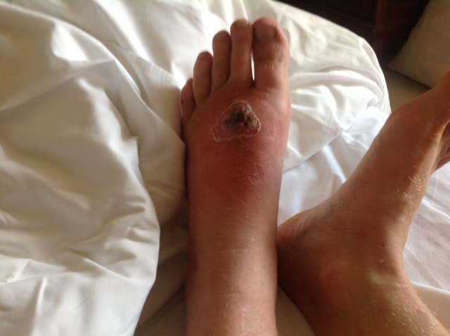
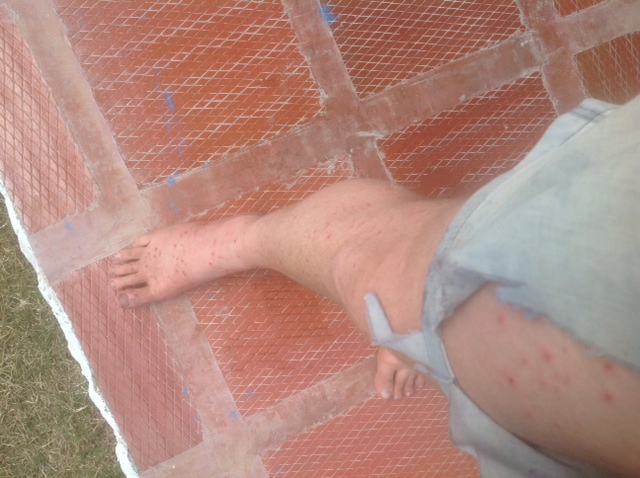
Here is a photo of someone after three days in the sierra without gumboots:

photo (3)

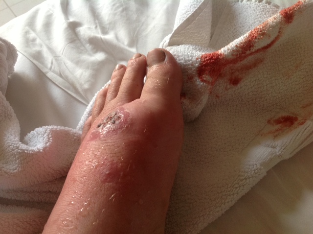
it might be hard to tell, but this persons legs are riddled with sand flea and mosquito bites. they spent 2 nights and three days up there.. they slept on the ground in a Kogi farm, instead of the recommended hammock, and due to the heat kept pulling out of their sleeping bag which was rated for two much heat.. most of these bites started to itch, indicative of Sand Fleas, and took about two weeks to heal once the poison was out of them (it is a pleasant sort of itch, the blood aside). A Cortisone shot was refused, but this likely would have accelerated healing. One of the bites got infected, and then blew up after another incursion into the sierra above Guatapuri, just due to the pounding on the feet somehow perhaps creating bruising where the infection could grow.

photo (4)

the bite in question became something called cellulosis I believe, it swelled up like a golf ball, then burst spontaneously while the individual was bed resting:

photo (5)

it was like a volcano of dark brown fluid, indicative of a blood infection. Eventually the scab was checked for something called Leismaniasis, a disease that enters through skin infection, but came up negative, but Staphylococus, also known as flesh eating disease, was present, and was eventually treated with doxycycline.

With more care this is all easily avoidable, but it points out the issues of especially sand fleas, kissing bugs and mosquitos, which are in many areas of the Sierra, from the beaches at sunset thru sunrise, to the newly cleared areas, to even Kogi and Arawaku homes. I never understood two things until now.. why South American natives often clear everything around heir homes down to dirt (I figured they just didn´t like putting effort in to landscaping, Mexican crews charge a lot to get here!) and why new Third World Homes are always made of Cement.. it turns out the thatch roofed homes we are so intrigued by end up being havens for disease carrying insect. Chagas in particular is carried by something called the Kissing Bug which bites people’s exposed faces at night. The classic photo of Chagas is this kid with a swollen lump over one eye.

389px-Chagoma

Alright, I will now link to real info if you are still curious on the possibilities:

http://en.wikipedia.org/wiki/Chagas_disease

So there are multiple strains of Chagas, and more than one vector, basically, different bugs carry it in different places.. but it is generally the Kissing bug, the Pito they call it in colombia. It is nocturnal like I said. The disease comes from it defecating near the bite. Pretty stuff. Wikipedia obviously describes this better than me.

Alright, Leishmaniasis. I recently met a guy who had been in the army in Amazonas for three years, on this beautiful river, and he got it once.

http://en.wikipedia.org/wiki/Leishmaniasis

LEishmaniasis comes from the Sand Fly, which is one of the banes here, and I guess it lays its eggs in you, so if it has bitten you, sometimes you will see a little black bump in the middle of the scrape.

Can´t forget ol malaria.. he gets all the attention, incurable and all.

http://en.wikipedia.org/wiki/Malaria

Categories
Uncategorized

The Climbing Possibilities of Colombia Today

Bogatenos are the most likely to be involved in climbing and mountaineering in Colombia due to what I will describe as facts associated with Sociology, not solely wealth, but Bogota is the Intellectual city. There is money in Medellin and in pockets around the country, but the type of counter-culture it takes to create a kind of climbing fervor seems to exist only in Bogota. To put it in perspective, people want their kids, including Botero when he was a kid, to be bullfighters in Medellin. Obviously Sir Edmund Hillary wasn’t exactly a counter-culture figure, he was just a dude who liked to climb, but in Colombia, a culture like this, both conservative and a bit risk averse, climbing is the kind of thing that comes from an upper class rebellious youth to some degree.
All the developed climbing is from what I can tell north from Bogota to Bucaramanga along the Cordillera Oriental, the Eastern Mountain Range that hovers over the Amazon. Bucaramanga is kind of the capital of all this, with an active paragliding scene there as well from what I can tell. There are also a set of snow-capped mountains in El Cocuy National Park within a few hours of there, unfortunately melting fast. Climbing Magazine profiled a scene in Suesca, about an hour north of Bogota it appears, which is alleged to be the best developed location in the country, with very hard sandstone.
climbing.com/route/ghosts-the-rock-gods-and-colombian-climbing/
this article also mentions an underground salt mine nearby with a Cathedral carved out of salt.. that’s pretty cool.

The Cordillera Central from what I have seen is stunningly beautiful, with waterfalls and rivers like one dreams of seeing, but it is mostly jungle and dirt,and well, perhaps there are lots of illegal activities going on in it’s hills. I have yet to see the Sierra Occidental except if you might describe the mountains west of Medellin as part, but they do look stunning, but again might not be climber country. To the South I know that there is a lot of FARC activity amongst the ranges closer to Cali, and as the ranges come together towards the Ecuadorian Border. As footnotes, there are places in the Amazon with exposed Limestone that look stunning, but I have no idea about security or climb-ability, and there is a small range of mountains in Sur de Bolivar that I glimpsed from the Magdalena, but this area is surely a no go zone, some hostages were taken just recently, as, to quote a boat mate, “That place makes some pretty high quality Coca!” and the FARC have conveniently chosen it as a good spot for the continuation of the people’s rebellion that COMINTERN even forgot about 23 years ago.
http://en.wikipedia.org/wiki/Serran%C3%ADa_de_San_Lucas
The up side is that they have kept it from becoming another of the vast cattle ranches that is Northern Colombia, and that are even creeping into the Sierra Nevada de Santa Marta.
Which brings us here.. There is plenty of climbing and mountaineering from what I can see in the Sierra, and if it was developed much, it has been years since anyone enjoyed it much, at high altitudes fortunately or unfortunately, but the weather can be crisp and dry even if the sun might bear down, but this brings us back to the subject of this blog.

Categories
Uncategorized

Land Mines in the Sierra?

Categories
Uncategorized

The Sierra Nevada de Santa Marta in Film

This is no IMDB, I am just poking around on YouTube, and found a few things. things seem to fall into three categories. Mamo worship, a kind of new age interest in the Natives of the Sierra, Shots from Airplanes or Airplane cockpits, and tourist stuff from Minca and the Ciudad Perdido..
Actually a friend of mine, after I told him I was poking around here, sent me this, since he was actually hanging out with a guy in Mexico at the time who happened to be one of the few ‘Civilizados’ who live in the sierra.. it was a neat coincidence.. the guy lived above Palomino, and was just taking a vacation to explore Mexico sometime around New Years of 2013. This guy who rented from my buddy Ozzy in Mexico for a few weeks, just happened to come by, actually knew some of the civilizados I met on my first excursion, who do live quite remotely, a days walk from the nearest drivable road, on the north flanks of the Sierra..
all this serendipity shouldn’t necessarily act as an endorsement of some of the cheesyness of this video, it’s a bit 80’s new age, actually, 1992 it turns out, but it’ the sierra, and this seems to be a good insight into some Kogi culture, since they seem to have been able to find a competent translator:
http://www.youtube.com/watch?v=U2tIVwGwiDc

To show how I kind of end up scraping the bottom of the Barrel pretty quickly when it comes to good documentation of the Sierra, here is an Italian film trailer with some good footage:

here’ some other stuff off of YouTube.. perhaps a bit like me, this guy could use some fact checking, but his comments are somewhat interesting, as are his blue (green!?) beard and zeal!

He actually references the above movie, which he says was made by a BBC director..

Here are two good examples of the genre of footage from planes transiting the Sierra, kind of proof that everyone is a bit surprised to see it there, and it puts in relief the idea that no one really has filmed from above treeline that I can tell:


One of them shows what appears to be the 5 blue lakes, and also demonstrates that the high peaks appear to be quite inhospitable as well as perhaps not of the best rock quality.
I did, by the way, do an IMDB search, just out of guilt for writing that I hadn’t when it is just a few key strokes away, and it turns out the Sierra Nevada de Santa Marta has two somewhat obscure references.. to use a concept from the book the Moviegoer, not many places are left un-certified by the rapacious appetite of the film industry, but unlike nearby Cartagena, it wasn’t exactly in a fantastic blockbuster like Romancing the Stone (c’mon, you loved that movie.. Turner and Douglas, what more could you ask for?!)
http://www.imdb.com/search/title?locations=Sierra%20Nevada%20de%20Santa%20Marta,%20Magdalena,%20Colombia
Here’s some short film that IMDB didn’t directly connect to the Sierra:
http://www.imdb.com/title/tt2201808/

Categories
Uncategorized

Why So Long? The 2 interconnected reasons why the Sierra has gone unclimbed for 20 or more years

So why so long.. in so many countries,maybe it’s Yuppie ambition, a chance to prove the leisure pursuits of your society, but it’s rare a mountain that is a superlative in a place goes unclimbed for too long. Heck, I once climbed the highest mountain in East Timor, which is a country of 1 million, but it had infrastructure to get to the top and a trail. A guide was 10 bucks for a half day affair.
The Highest Mountain in the United States and North America, perhaps in part due to the 7 Summits phenomenon launched by the Texas Billionaire Bass Brothers with their endeavor and book by the same name back in the 80’s, is called Denali or Mt.McKinley, and it has 5 guide services plus independent parties from all over the world attempt it, usually about 1300 people per year attempt, and annually about 500 make the summit, sometimes dragged along by their guides, but nonetheless successful. Such infrastructure exists all over the world, from the Himalayas to the Alps to the Rockies, and in South America in places like Aconcagua, Bolivia, Ecuador and Peru, and in Colombia supposedly in Bucaramanga.. so why not the sierra…
Well, i’ll toss out a first casual reason, not the two I plan to explore in greater depth in a moment, but it’s an 18,000 ft mountain, 5700 meters, and that is about 1000 meters or 3000 feet past anything an armature would want to polish off in a day or two.. it’s up there in a realm that puts it amongst the biggest things on earth, and even though it is in a tropical zone, it’s high enough to be very tough from the perspective of altitude, the possibilities of HAPE and HACE, and the sun in punishing.. It’s not in the much vaunted ‘Death Zone’, the stuff of Men’s Health and Outdoor Magazine tabloidal legend, which lies about 26,000 ft.. in fact, I’ll legitimize all the hype with an actual Wikipedia Article about it..
http://en.wikipedia.org/wiki/Effects_of_high_altitude_on_humans
but it’s high enough that it isn’t a Colorado 14er on a weekend.. not to be, well, tabloidal,but you can die at these altitudes from exposure and altitude issues alone, even if preserved from the additional hazards of alpinism. But these reasons enough haven’t prevented people from climbing many a similar and higher mountain in thousands of places around the world.. so what is it preventing people from going up there?

Two Buzz Words..Sacredness, and the FARQ.
For the uninitiated, Colombia has been engaged in a Civil War for some 50 years, and longer if you delve into what is a long national history of fratricide, driven by a theme that will be familiar to many Americans, two political parties, one of the landed gentry for a long time, and the other of the lower class and intellectuals, basically the conservatives and liberals, a bit more complex than this, but the conservatives drawing their lineage from the beliefs of the National Liberator, Simon Bolivar, and the Liberals believing in the somewhat more law based opinions of his main rival, Santander.
http://en.wikipedia.org/wiki/Francisco_de_Paula_Santander
To place them in another context, in Mexico, Santander would be Benito Juarez, and Bolivar some combination of Cortez and Porfirio Diaz, or in the US, Santander as a vindictive Thomas Jefferson to Bolivar’s somewhat less restrained George Washington. All this to say, that at some point, the followers of Santander and a more extreme group that started to consider itself communist, broke off after an incident in a place called Marquetalia
http://en.wikipedia.org/wiki/Marquetalia_Republic
and began waging a war against the government organized as a group called the FARQ.They fully embraced a communist ideology supposedly in 1980 at their 7th congress. There were two other significant Left wing insurgent groups in Colombia, M-19 and ELN, but the FARQ and the Colombian Army are the Major Role Players in the Sierra Nevada, and the paramilitaries were but are no longer a significant factor that I could find, other than as a persistent memory for some.
As the FARQ expanded, financed by some assumed combination of cocaine revenue, protection rackets, and support from Soviet Block countries and perhaps even the Peruvian and Venezuelan Governments at times as has been alleged, they opened what they called Fronts around the country in Rural Areas. The one in the Sierra Nevada De Santa Marta, Front 59, at one point had more than 800 members I was told. I will reveal the present disposition in a post entitled Current Security Situation.
In 2002 there were major combat operations, with the military moving into the sierra to displace the FARQ. They removed them from many a town, including Pueblo Bello without a fight, but between La Minah and Guatapuri, 200 people were killed in everything from Executions to Infantry Combat. The people there are relaxed enough, but there is a way in which they can be comically indifferent which seems to be a defense mechanism against the trauma, and this behavior just a few valleys away on either side of the Sierra was not evident. The Operations were ordered under the NEw Administration of President Uribe, who got elected promising to take down the FARC, who amongst other things had killed his father when he was younger in rural Antioquia. The FARC at it’s high point literally administered to some degree 10% of the municipalities in Colombia, and it wasn’t all in once place, they were all over, including Guatepuri, Pueblo Bello, and i have even heard they ran Palomino to some degree, and definitely the villages above it. I have seen the same phenomenon at work in the Darien Gap, where the FARC are the de facto big brothers of the Indigenous groups who live closest to the colombian border, away from Panamanian infrastructure. The Sierra Marta was a FARC territory, and they liked and treated the Koguis quite well from what I have been told, but killed more than a few Arawaku and Kancuamos, and I would assume they treated the Wiwa’s similarly to the Koguis.. I have had Arawaku’s and Kancuamos tell me they were quite pleased to have the Army come in 2002, although it has accelerated the forces of westernization in some of the towns, the Koguis and Wiwas are blissfully indifferent to this, and the Arawaku’s have a sophisticated combination of ways to deal with maintaining their lifestyle while working with the outside world. Like I will describe later, the Kancuamos have been westernized since long before the FARC came around.
All this to say, that as nice as the FARC might have been to some, most mountain climbers tend to be from the Elite or Bougoise, and these are not people who should be messing with the FARC, it’s like a mouse teasing a cat, and it didn’t happen. There was one famous exception, a group headed to the Ciudad Perdido (Lost City of the Tayrona Culture, the predecessor culture to the present day indigenous groups which peaked and fell in pre colombian times, rediscovered in the 70’s, and a popular tourist trek from near Santa Marta and Minca), which seems to have continued tour operations even as the war raged in some sort of truce, were kidnapped by a combination of the FARC and ELN in September 2003, no doubt when the Uribe ordered offensives were creating pressure, officially as a protest of alleged human rights violations by the military and paramilitaries. The last of the 8 individuals was released after 3 months. There was paramilitary involvement in the incident as well. Tours resumed in 2005 to the ciudad perdido. I haven’t looked too hard, but I haven’t heard of any other incidents between the Guerrillas and Climbers.
But now I must introduce the Sacredness concept. Many of these tribes will argue that the Mountains are sacred, and cannot be visited by outsiders. This is a tricky ball of wax… Sometimes when I hang out with an indigenous group, i sometimes wonder how much of what I am being told is what they think I want to hear, how much of it might be regurgitated hooey that NGO’s and occasional hippies that come begging for validation from the Mamo’s, because their dad was some businessman prick who didn’t teach them about spirituality, the local term for Religious Leaders or Shamans. Hang out in traveled areas of The Sierra a bit, and you will see these guys, hippies from Bogota looking for answers and a mouth full of Coca focus. Every time I heard this term, I wondered if the whole Sagrado thing was pumped up by outsiders, which the Arawaku’s seem to take seriously on occasion, or was it an excuse to keep people from getting kidnapped by the FARC which would create hassle for everyone. You will notice in Colombia that a lot of people are quite more disposed than would normal in a lot of places in the world to putting up with problems, since for 50 years anyone who complained ended up with a bullet in their head. This sacredness thing gets tossed about a bit.. oh, the Koguis up there won’t let you to the snows, it’s sacred.. oh, well, you’ll never get permission for that particular spot, it’s sacred.
When i hang out with the Arawakus, I feel like if I made a strong enough argument, proved the FARC were gone, and offered to involve them in an ascent, I could get through. With the Koguis around Guatepuri, I feel as if a little help from the military in terms of conversation with the leaders to say there is no danger, maybe even an escort, the Alcalde (the municipal government) and a little money in the local leaders pocket might get me access as well. One Soldier told me i could get up there through Minca, but I am not sure if he was confusing the Ciudad Perdida with the High Peaks region, but I kept hearing the sacredness thing, and I wonder how true it really is, how much they would hold to it, and what combination of gifts, involvement and logic might break through this barrier.. I have some hunches…

Categories
Uncategorized

Photos of Chris’s Peak

http://ko.advisor.travel/poi/1003/gallery
when you see a lake, it appears to be from the south.. when you see black rock slides, I think that’s the north face… when you see a glacier, I again think that is the south side…
http://www.andes.org.uk/peak-info-5000/colon-colombia-info.asp
for some reason I love this picture in particular..I imagine what it was like to go up there in the 70’s and 80’s:

20130118-215905.jpg
http://www.andes.org.uk/peak-info-5000/colon-colombia-info.asp
and this one intrigues me as well, showing both Chris and Simon (Pico Simon Bolivar), chillin’ in the afternoon sun..

20130118-220057.jpg

A Link to photos of the highest peak of every country in the Americas:
http://www.taringa.net/posts/imagenes/13584798/Puntos-Mas-Altos-de-America-_por-paises_.html

Can’t say the Sierra Nevada de Santa Marta is the prettiest one,but it is one of the highest…

Categories
Uncategorized

Approach 3: The Long Valleys from Guatapuri

This appears to be the most conventionally promising, although it ain’t easy, and requires a consistent hike up either of two long Valleys Running east west from what appears to be an old glacial junction near the village of San Jose, about an hour in by foot from the Road Head in Guatapuri, which is at about 5000 ft. the Road is Paved to Pillal more or less, and pretty much paved from Pillal to Atanquez, but from there it is a combo of cement tracks and dirt to Guatapuri, where you set out on foot through this Kancuamos Village, essentially modern, up the Guatapuri River (which runs down below town all the way to Valledupar, as the town straddles a divide between two watersheds, the one you were driving through from Pillal and Atanquez and La Mina, that you crossed at a popular swimming spot, being the Rio Badillo ). the last part of this road is best done in a raised vehicle at least. I did it on foot half way up and all the way down from Atanquez, and it’s not horrible, like the road from Pueblo Bello to Nagusimake, but I had to jump off the guy’s motorcycle a few times when it got rocky towards the top (it wa getting dark, the ride was cheap, and kind of fun I won’t lie) There is regular service in a bunch of old Land Cruisers to Guatapuri and it’s sister town whose name now escapes me, a few hundred yards to the left from the last junction which is pretty much at the town by the school and the pass into the Guatepuri valley.
It looks like about a two to three day hike to base camp from here,but it also looks like a beautiful hike up a deep valley. The Valley to the North, the Guatapuri, has a series of lakes that would no doubt be pretty. The other river, which seems to be called the Donachui, is the southerly of the two Long Valleys, and is a little trickier to get into from the Pueblo of Guatapuri, since you have to go over a bit of a pass. I can only imagine what it holds for beauty. The two mountains are split by a mountain called Sinimin, which is over 4000 m, and has the appearance of a Papal crown. It would be about 20 miles up each of them to the 5 Blue Lakes, with a 7000 ft elevation gain.. steady hard work.. You are above tree line pretty quickly it appears, as these deep valleys don’t seem to allow a lot of sunlight, maybe at 7000 ft from what I could tell.
San Jose seemed to lie at about 6000 ft, and is the last outpost of Civilizados in the Guatepuri Valley, the nickname for educated non indigenous people from the low lands. There are basically two nurses of sorts, a male and a female when I was there, who look after the Koguis in this valley. the buildings in San Jose are a combination of cement for them and thatched huts for the chief who lives there with what might be a bit of a harem, Jose Gabriel I believe was his name. I didn’t talk to him but saw him, and he was an older looking Kogui with a wry smile it appeared. Going furthur up this trail would involve either sneaking past or massaging him, and the first step would be engaging the local municipal head in Guatapuri whose name is______
From there, maps show a few more settlements, then just a long streatch of steep valley running west to join a plateau where the 5 Blue Lakes are. There are a series of Lakes as well in the Guatapuri Valley, the Donachui might have one or two but is mostly river. I have no idea how passable they are, or how difficult it would be getting from the head of the Valley to the plateau, or if they valley walls might be so steep that it becomes impassable, or whether there are boulder fields or waterfalls or cliffs that block the valley.. the only way to find out I guess is to go there or find someone who has… My instinct tells me that the north Valley, the Guatapuri, is the most straight forward of the two, to the lakes. When I asked a guy in Guatapuri how far it was to the sierra, he motioned towards the Upper Guatapuri Valley and said 2 days.. that just might mean “we have big parties up there all the time!”


Categories
Uncategorized

Good Sources of up to date Information on Colombia in English

A Climber should be able to just focus on the Climbing, but this is colombia. I have found that as I settle into the country, I find myself catching things on the news and wanting to know what they are talking about due to the limitations of my spanish, and I started to search for sources of info. my spanish is good enough for conversation, but the News is on a higher level of vocabulary is my excuse.
http://colombiareports.com/
Colombia Reports has turned out to be quite handy. If something happens, anywhere in Colombia, and it is potentially news worthy nationally, which includes almost every guerrilla/terrorist act, criminal organization, plus a lot of other things and even some humor, they will cover it. What also makes it nice is that it functions a bit like a data base, so you can read about a place, and the place and department name will pop up on top, and you can use this to research back into a place. This is helpful because it will tell you how ‘active’ a place might be if it isn’t just local crime, which foreigners tend to be a bit immune to in Colombia.
For deeper insight there are a few:
http://talkingaboutcolombia.com/
there might be a slight liberal bias here, but 50 years of civil war, and more troubling, growing up in Canada, will do that to you!
This blog appears to be written from Bogota by a Canadian raised Colombian named Paula Delgado-King.. like all Colombians, she looks cute!

Home


insight Crime is an interesting idea. I picture a bunch of guys dedicated to the truth behind a very locked door, hopefully someplace in the states. I bet they rarely order pizza from the office.. the coverage is good, including of colombia, but it intelligently treats all of Latin America as once place for the sake of understanding how drug trafficking, the overarching story here, involves the whole region. There is a similar focused just on Mexico called Borderland Beat, but this is about climbing, so I will focus on that.
justf.org/blog
Just the Facts is officially supposed to just cover US activities in Latin America, which it does well, and without much bias from what I see.. it also covers news and trends that might be seen as diplomatically worthy.. you can get a sense of how governments see what is going on. Again, not exclusively focused on Colombia, but interesting.
Speaking of Climbing, Peakery does display some info on colombian peaks:
http://peakery.com/cerro-boquinete/