There must be a thousand rivers like the Cuyahoga in America, and ten thousand around the world.. it runs only 84 miles, only drops 500 feet, drains only 809 miles of America’s 3 million. On top of that it drains in the ignominious City of Cleveland, which Eddie Murphy implied many years ago in Beverly Hills Cop was not much of a place for classy execution, well before I ever got to see it with my own eyes and give it a personal judgment of coming back but hardly Paris. Never been off the highway in Akron, but they did produce LeBron. The River Cuyahoga might be able to flow a half million CFM into Lake Erie, and it’s got a reputation for some pretty scenery and ledges in it’s upper reaches, so impressive they were made a National Park, but it’s hardly a world class waterway. What made if famous beyond Ohio was this:
This is a picture of the Cuyahoga someplace I am pretty sure in Cleveland, on fire in 1952. It caught on fire some 13 times between 1868 and 1969 it is reported, about every 7 years it sounds like, and who knows how many minor fires were snuffed out that didn’t make the broadsheets.
The Cuyahoga wasn’t famous for this:
it was famous for this:
and this: it was biologically dead from Akron to Cleveland, some 50 river miles, toxic and anaerobic, unable to support life, and more a gutter than a river as it ran between these two famous industrial cities, dredged for navigation, dammed some 9 times a sluice for pollution going out and raw materials coming in, looking like this: but even that didn’t make it famous, that wasn’t an uncommon sight in America either back then, as rivers from the Delaware, to the Hood Canal, to the LA River became sad reflections of themselves, sooty industrial monstrosities.. that was about every urban river in America and a few rural ones to boot in places like coal country. What made it special was catching on fire some 13 times ( how the F@#$ does water catch on fire!?), and finally that picture above of the fire making it into Time Magazine in 1969 ( August 1, 1969 America’s Sewage System and the Price of Optimism), right when America’s optimism for the moon landing made it particularly embarrassing how shabby we had let things become. We had perspective now, we had photographed the world from above, and to quote the famous adage, if we can out a man on the moon, why the heck can’t we fix a problem like this!
The fire and the Time article some 48 years ago have been commemorated many times, having helped launch Earth Day and mass adaptation of environmental values that were channeled by Richard Nixon into some very important pieces of legislation including the Clean Water Act.. that was the nadir, nationally even, and now things are perfect nationwide. Done and done, right? Well, not really, because the Clean Water Act focuses on pollution, and pollution was only the most obvious problem back then.. frikin’ river catches on fire, and people got some explainin’ to do, right Tommy Boy, but think about it, pollution is only part of the problem, but the only part the Clean Water Act had a real mission to solve in 1972 when it passed, most publicly as a result of this event. Sure the Cuyahoga still has pollution issues, it runs through two major cities Akron and Cleveland. Impervious surfaces, sewage, automotive and industrial run off are just a few to mention almost anyplace people live near water, and where you find water, you almost always find man. While we have controlled the old boogie men of industrial waste and pollution, we came up with more nuanced bad guys like the aforementioned, contamination not just from major big bad factories, which they call major point source pollution, but leaky car oil pans and radiators and fecal matter from walked pets are the potent but somehow less menacing and horrifying new bad guys; fix a big problem and move onto the next one down the list, and that is what makes what is happening on the Cuyahoga so impressive, because they are moving down the list well past where anyone might expect for a river that had so many problems, nor resting on their laurels. They have blown past storm water runoff and are now taking on derelict dams! Them kids at Patagonia just told the Starbucks set that dam’s were bad three years ago, but them Trump voting hard heads in Ohio have been ripping out dam’s for more than ten! What am I talking about? We’ve come a long way baby.. enter again one of my favorite new themes, dam removal, stage right. Why I became curious to research this is I was poking around looking at data from American Rivers for a previous post on Dam Removal going Prime Time, and I kept noticing a particular river on the lists of the 60 or so dam’s removed every year. it wasn’t high profile projects like the Klamath or the Penobscott, where Endangered Species Act and blue state political inertia is making things happen, it was a river in Ohio with a familiar name. For one river this small, no matter what the reputation or location, to have 5 dam’s removed or diverted in the last 15 years with at least one if not two more in planning might be a record, per river mile or by any measurement. To have this happen in the perennially environmentally distracted heartland is almost astounding. And the to such a iconic river. What was happening on the Cuyahoga? I had to ask myself.. a whole lot it seems, in the right direction after a whole lot of industrial might made it such a laughing stock.
Cuyahoga River Dam Status
Upriver to Downriver:
1. Lake Rockwell Dam no plans.. upriver of Akron, and provides the city with it’s drinking water
2. Kent Dam removed 2004 Kent 3. Munroe Falls Dam Removed 2006
6. Gorge Dam ( AKA First Energy) removal 2019 ( waiting for funding) Akron 7. Brecksville Dam State moving to remove it in 2017 or 2018
multiple tributary dam’s have been removed as well.
What’s powerful about this from a narrative perspective is that there are large water falls behind the Gorge Dam, just yards behind it. If it is removed, they will be restored in some form!
If that dam is taken down, there will be something like 60 miles essentially wild flowing river running from Lake Rockwell Dam all the way down to Lake Erie.. this would be a huge benefit to the Lake, which is experiencing horrible algae blooms in part due to the increased water temperatures that come with stagnant waters. State Government and the EPA have so much momentum to fix this river to a bar set high for water quality scores that they seem to be heading towards a wild restoration, which no one would have dreamed of so long ago when the river was dead and on fire less than 50 years ago. It’s like going from Quadruple Bypass to Marathons.. turning Calcutta into Copenhagen ( if that’s progress…). Making William Hung actually sing and dance like Ricky Martin, it’s almost seems implausible. If you figure on the 30-80,000 dams nationwide that the greenies keep trumpeting about, there are very few free running stretches of anything, especially this close to population sources, industry, and agriculture and east of the Mississippi & Rockies, all situations that demanded river control in the old school tradition.
Mayor Carl and Cong.Lewis Stokes of Cleveland
What also impresses is that you have a state with a politically adept and not foolhardy Republican There might be a thread of inevitable progress here. Ohio is pretty far east.. it’s a place where people have made mistakes and had time to move away from them.. while the west stumbles into the reinvention of the wheel, perhaps Ohio is joining the east coast in acts of societal maturity, watching aging infrastructure through it’s decrepitness impose something different, and a place so long from it’s wild roots somehow recognizing intuitively what might change it’s moribund economic state, a return to a pre-industrial environmental state. While so may rivers in America languish without momentum fighting runoff, dam’s, diversion, and neglect, the Cuyahoga seems to be benefiting from how bad it got, but in some ways it isn’t.. It is benefiting from how bad it got that it might have contributed to laws and programs that fix the problem, but they weren’t intended for it. The US and Ohio might recognize the symbolic significance of this river but they don’t necessarily account for it’s momentum. If you talk to those involved as I was able to do a few busy months ago, they will tell you that the laws and efforts that are setting the Cuyahoga free as as much from the regular band of state employees and local activists as from any celebration. It all supposedly started with a pair of power brothers, the mayor of Cleveland and his brother a long serving US congressman Carl and Louis Stokes. When Carl became mayor a year before the ’69 fire he was on fire himself and talented to do what the city needed to recover from strife and decay brought along by so many things from pollution to racial issues to urban decay and steelbelt economic woes. He saw the river as a worthy way to turn the town around and his emphasis flowed not only up river but around the country. The Cuyahoga as the symbol of pollution became the focus of improvement, and guys like his brother pushed those ideas in Washington as well. A framework built locally but to the benefit of all.
Gov.John Kasich signing a bill to give ODNR more power in Lake Erie
Governor in John Kasich who hasn’t tried to strip or hamstring these efforts as happens out west, where water going anywhere but into a dam or onto a plant is argued as wasted by a cranky contingent of industrialists. While Ohio DNR might have cash flow issues like any well meaning state bureaucracy is bound to, it’s still doing it’s job, it hasn’t been politicized or stripped bare so much that Dam Removal projects couldn’t happen on his watch. Fish don’t know party, and clean water doesn’t only impact one side or the other, and it’s neat to see the wheels of government doing what they are supposed to in such a famously contested state. In the traditional narrative so espoused right now by partisans, African American Politicians aren’t known for prioritizing the environment no more than Republican Governors are. It appears that a cleaner Cuyahoga has become a shared value. And don’t forget the activists. Their work progresses, to the point of celebration, and is now moving through hurdles to an almost pristine state that barely any other river this size could imagine benefiting from east of the Mississippi, let alone west of it. This river, diminutive though it may be, runs through so many populations, rural and urban, left and right, green and rust colored, that it’s great to see it as a uniting force in a better life for all than a source of contention.. it’s about two visions of America experimented with and now redeemed.. industry exchanged for beauty as time and circumstances allow. From a fiery symbol of what was broken to now almost a model of the pristine. Something is working here other than the steel mill. What can I say.. Cleveland ( and Kent, and Akron) Rocks!
I’ve got a thing for Utah.. it’s wild, it’s serene, and it’s beautiful. Say what you want about Mormons, they run a tight ship and make great neighbors.. it’s a pretty good place. While I spend most of my time when I am there exploring the canyon’s of it’s southern reaches, one of American’s world class locations, I’ve been all over it, and one adventure took me over one of it’s rare and actually closed landmarks, in an RV with a crazy homeless dude no less. This is how I came to care about the topic of this blog, the bridge over the causeway that will hopefully contribute to the restoration of saline balance in this great body of water, the largest salt lake in the western hemisphere, and one of the most unique places in America.
People know the Great Salt Lake from the city named after it.. few actually see the lake proper.. you can spot it landing at SLC airport if there isn’t a layer of fog or a bad inversion, or see it’s edges from I-80 as you head to Nevada, past Bonneville, or maybe from the houses on the hills above the city that shares it’s name, but to the majority of the people of Utah, the lake is something you don’t think about much, it’s useless and somewhat in the way; Thus is the practicality of the Mormon pioneers. While Brigham Young said “this is the place”, this place had a big salt lake that wasn’t much use for farming or industry until brine shrimp and magnesium harvesting were figured out in this century.. but it was a nice barrier to moving further west, and the rivers that fed it fed their new civilization, which they eked out of Ute land and made into a successful civilization, territory, and then state of the great United States of America.
The lucky and the curious might head out to Antelope Island to take in the view and see the Buffalo, and the truly adventuresome might head out onto it’s waters to explore, or work, but I assume it requires frequent new paint jobs and a comfort with a silence hard to explain. Naivete led me to my greatest Salt Lake adventure. I was returning an RV from an adventure called Burning Man ( I showed up with skepticism but admit I saw something amazing there as well) and spotted a road to what looked like a marina on the west side of the lake on a DeLorme Gazetteere I purchased to widen my understanding of Utah, like I do in a lot of places.. if your map is a highway map, you only see the highways my thinking goes.. Blue Highways are for William Least Heat Moon.. I like dirt roads. I had left Burning Man a bit exhausted, and followed dirt roads east from it that I saw in my companion Nevada DeLorme Gazetteere, and it had been edifying, filling in amazing blank spots on the map north of the Humboldt River valley that most people know, again, the route of I-80-, past mines and abandoned homesteads, relics of the great drive west. When I returned to the highway with the plan of cutting through the Dugway Proving Ground to said marina, a place called Lakeside, I knew I had a few days left on my RV contract, and needed to clean the thing as well, so I figured my little turtle home, self contained in all aspects, was just right for this exploration. I would sit a few days, relax, ponder the lake and the desert, maybe meet some funky people and clean the dust out of the rig. Also as I returned to the highway, I picked up a rider, what seemed to be an old hippie, and we conversed somewhat easily at first, even though there were some warning signs, a refusal to drink water or eat food, and as time went on it got a bit weird, but I’ll get to that.. so I picked this guy up, and he seemed up for anything, told me he had no plan somewhere in north east Nevada,, so I turned north a few hours later, west of the lake, and started heading north through the desert to this alleged Marina.. it was right near what the map said was a railroad causeway, and it was one I had read about before.. the Great Golden Spike on the Transcontinental Railroad was driven in just north of Promontory Point, connecting east and west by railway, some 80 years before we would successfully do it with the Eisenhower interstate system for the automobile. Originally the railroad went around the lake to the north, but engineers and railroad barons like a nice straight line, and they constructed the railway across the lake, well two spans, touching at Promontory Point, called the Lucin Cutoff, and between 1902 and 1904 constructed it across the lake as a trellis. The nice thing about a trellis is that water moves under it no problem. it’s just a collection of pilings.. if anything, the strip of railroad cools the lake just a bit with it’s shade and stops it from evaporating away too fast, but progress is progress, and in the 50’s, our restless and now quite capable nation of eager beavers did what it did so many times, in the Everglades, on the Colorado, all over, and it built a causeway out of rip rapp and the natural circulation of the lake was halted.. there were a few culverts, but they started to sink under the weight of the train and were closed. The great Salt Lake became two lakes, separated by one great railway, and problems began to occur.
As I arrived at the gate of Dugway, my rootless companion, already coming across as a bit odd, expected from a 60 year old hitchhiker, started to act a little weird.. the only radio station I could get out there was broadcasting Sean Hannity. I am nervous because I know Dugway is a place for Secret Squirrel Stuff, but my map seems to indicate I can drive right through the place to the north end of it where my marina should be. Sure enough, the road goes to the right past the gate and keeps going.. no need to explain myself to the Air Force guys, but my companion gets more ornery. I ponder dropping him off with the air force dudes but feel that would be a betrayal, and raise a bit kerfuffle.. As we drive over these dramatic hills and rock edges, sage and scree, my companion starts to blame Sean Hannity for the flies buzzing around the cab of the RV.. for making the flies attack him…
he says as much to me..I’m realizing that he’s not all normal, and I start to worry.. but no fear, at that marina there will be people, life, services.. people to talk about the area with.. he’ll blend right in, shaggy and hippie as he is, and get some sleep and calm down..
but my alarm increases, he mumbles more, and when I get to the anticipated marina, or where it should be, it ain’t there..there is nothing there.. no buildings, no people, no marina, no salt water toffee, just a gravel parking lot where someone once did something…
I drive in circles for a bit, pondering my situation.. I think about stopping and dropping him off, but realize he would starve to death.. we are what most people call the middle of nowhere. I don’t come to a halt because the idea that I am driving feels like protection, I keep moving, thinking he may be nuts, but won’t attack me while we are in motion, since by this point I have accepted that he’s out of touch with reality, but not suicidal.. I see the causeway, and there is no gate.. I hate backtracking, more than I hate an insane man in my RV, and I put the pedal down and head for the causeway. Soon I am on it, RV and all, and crossing towards promontory point in the distance.
It’s beautiful, like driving on the water it’s self. there are mirages.. the air is fresh, well, fresh by desert in late summer standards.. you can smell the salt, feel humidity, and after a few miles a train goes by and the conductor let’s all hell go on the horn.. he’s as surprised to see me as I am to see him.. I keep going, realizing I might be spotted but I might as well make the best of it.. I want to cross all the way now, get to Promontory Point, find people there, and drop off Psychotic Jeffrey Lebowski, Batty Bob Segar, before he kills me or I kill him.. it’s exhilarating.. I see the two colors, one side saltier than the other.. it’s blazing sunny, and the mountains shimmer in the heat all around me.. I want to stop and take it all in but I am pedal down, even though even he seems to notice and be taking it in.. little by little Promontory point arrives, not before I pass another train, and when I get there, hit land from the gravel road that runs the whole length of the causeway, I find an open gate at the end, but not much approaching civilization, just some abandoned industrial yards, evidence of shrimp fishing fleets gone bad, and some neglected state parkey stuff.. I spot the causeway going east again, the other side, but I know I have to go north to some town to unload my hazardous materials passenger. I’m on the road along the east side of Promontory Point.. it turns out it’s quite long, and I’m gunning all 8 cylinders.. I pass small Mormon looking settlements but again, realize this isn’t the place to leave him. He says something to me to the effect that I don’t have to drive so much after more than an hour of awkward silence.. he’s a bit stunned.. I realize he’s relaxing and coming back to earth, but I resolve to get him back to population, and still finish crossing that causeway, to not let this screw me up.. I drive and drive, past the golden spike national historic park, past some odd rocket factory, and finally make it to the junction of I-84 and I-15, pulling up to a gas pump.. I sadly inform him that this is where he and I part fro the safety of the fuel island.. he offers to buy me dinner at a truck stop in the waning light, but I politely refuse, slip him a 20, and wish him luck. I’m obsessed with this causeway now..
new and old..
if I can make it across half, can I make it across the whole thing.. I’m intrigued, by it’s history, and by it’s current environmental impact.. I had read about the lake being split in two once.. the salinity greater on one side, and how hard it is to explain to people who see it as a wasteland, the practical Mormons who control Utah Politics, and the thrifty Railroad men. Its hard to advocate for a lake that no one really boats on, lives on, swims in or makes much money off of (brine shrimp, AKA the sea monkey industry, used for I think animal feed and hard to tell what else, does pump 57 million into the Utah economy, but that’s not much in the grand scheme of things these days..). It’s almost like the great test of environmental honor; you can only argue for the Great Salt Lake on it’s intrinsic environmental merits.. it has no NIMBY (Not In My Back Yard ) bedfellows, its only worth what it’s worth to shrimpers, magnesium harvesters, flamingos, and the daring few who venture out on it, driven by a mad companion or just madness themselves. I drive back down the point through the dark, and find what I think is the west entrance to the east causeway.. ( it tunrs out mit might have been a water control structure north of it) it’s got threatening signs.. I can tell many more people make it here than the set from the Spaghetti Western I departed from north of Dugway Proving Ground, but the gate is down, and I roar across.. I pass little industrial facilities, that look like pump stations, go over little archway bridges with sill more threatening signs, and even dim my headlights.. I start to worry.. there is an air force base to the east of me.. will it dump me into that.. are there yet more AFSP watching me with Nogs right now wondering what the hell is up with the RV crossing the causeway at 11pm.. the terrorists in Back to the Future had an RV (OK, a VW bus, but close..), could this be a terrorist attack.. can we kill them boss!? I end up on dirt berms.. I’m driving with my headlights off again, and feel the calm of marsh around me.. the road is wide again.. I have made it across.. arrested or not, I sate my obsession, and ponder how I might explain this to a judge.. I just had to see it your honor.. explorer’s burden.. I realize I am a bit lost, know I am still headed east-ish, but I see pumps running and salt lagoons filling up and emptying, evaporating ponds like at the south end of the dead sea. I have seen salting operations up close in Namibia and Mexico, so I know what is around me just by the pumps.. I come across a vehicle, and know the gig is up.. his headlights come on, and he pulls next to me, and doesn’t even ask, just sees the RV and knows it’s too weird to be dangerous. I think he was Native American.. he gives me a wide eyed look, and I shrug and tell him I am lost, and he motions me to follow him to the gate, with a funny smile and shrug. he leads me out past what turns out to be the Magnesium plant.. the tracks have disappeared to our south.. it’s a big factory, roaring in the night, dark but for lights on the smoke stacks, and we end up at a security shack at an entrance.. I pull up.. my guide slides out of his truck and walks to the security guard, a nice earnest young Mormon guy, explains coming across me 5 minutes ago to him, and he’s so amused that I somehow got back there with an RV he just offers to let me go.. he tells me I was trespassing, but kind of shakes his head in amazement, and I smile and tell him I’m just relived this ain’t the air force base. He laughs, and asks me if I crossed the causeway.. I demure, say something garbled, then I press the advantage and ask if there is a place to sleep by the lake, which is all I was looking for just hours ago.. he tells me to take the road out, and take a left then a right off the road from the base.. he and the Indian are laughing and staring at me as I wave goodbye and roar off.. don’t that beat all I can hear them saying.. I find my place in a state game preserve, stare at the stars to relax, pass out, wake up the next morning, cook breakfast, and wind my way down to Antelope Island for my last night, and yes, I pay the entrance fee and for my camping spot like a normal human being. As many of you know, as with global temperature, nature isn’t static, but it moves slowly, like a bureaucrat, or a sloth, and most things have time to adjust if they haven’t painted themselves into an ecological corner…when man is short sighted, he creates changes much faster than nature can adapt, and he starts to wreak havoc with natural balances that a lot of things depend on, migrating birds, shrimp, animals, and even nature lovers.. survival of the fittest argues that Adaptation is the Rule of the Wild when change is inevitable, but there is a sensibility of fair play that is being applied by conservatives and liberals alike in the Global Warming Right, in the moves to restore the Everglades with Bridges and maybe save the Vaquita with more fresh water flowing into the Sea of Cortez that says that it’s not fair to change things as quickly as humans do to an ecosystem, intentionally or not, shortsightedly or not, which grates the conservative sense of fair play in a place like Utah the way a deflated football might.. it just doesn’t seem right. The hope comes in here.. after that adventure, when I got to the Little America Motel, my favorite SLC haunt, I did some internet snooping before a truck driver buddy of mine showed up to bring me back to Reno for my next event, and I learned about the emerged two lakes, the difference in Salinity, dramatic enough to change the lake to too salty on one side and not salty enough on the other, and I learned how the lack of circulation is helping evaporation, keeping the water from sinking and cooling and circulating in it’s old way like the inter-oceanic heat conveyor, Thermohaline Circulation, on a small scale, and making the lake smaller than it has been in a while. while there is no direct correlation in the chart below between lake levels and the causeway or maybe global warming, the salinity thing is quite obvious, and visible..
The shrimp have a goldilox dilemma.. one side is too salty, the north, 28% salty, the other too sweet, the south, declining to it’s present 11%. Ocean water settles in at 3.5 %. It happens because there are no major natural tributaries to that north west corner of the lake other than rain water, which is as you know not in prodigious amounts in the desert, and that area, unlike the south and east parts of the lake, doesn’t have the runoff from the grand Wasatch Range, famous for it’s powdery skiing.
The lake used to be someplace between the 11% and the 28% salinity mark where it maxes out the holding ability of water, and starts to form a film, as it is on the north end now 5 feet thick, like a liner of sorts, all because of my buddy the causeway.. it’s not in the middle where it has been for a few thousand or more years, and that’s affecting the shrimp, who know their niche, and the things that feed on them, birds that end up in Alaska, Russia, or South America to name a few spots. This isn’t just a local issue. If affects habitats far and wide if the lake can’t support it’s transient, let alone permanent population.. What if people starved at Salt Lake City Bus Station, before catching the next ‘Dirty Dog’ to California.. someone would say something I would imagine.
So this is where hope jumps into my RV, because the conclusion I came to a few years back was that this problem had few advocates and no solution in site.. by my present math I was wrong, because I know how long it takes to design a bridge, and it appears one will be done by October of this year, the year of our lord 2016. It turns out the railroad company, Union Pacific, the dominant western freight server which took it over from the former Southern Pacific Railroad Company (links for you foamers !) sometime in the 90’s after SP’s dissolution, had taken note, and was getting a bit embarrassed by the situation perhaps. Why? Railroads have become a symbol of efficient, AKA green transportation recently, as the world fights to end the carbon era.. if you are going to maintain a modern lifestyle and fight carbon, the iron horse is considered an ingredient in that effort since it’s more efficient than a truck, airplane and I think even a boat in moving cargo around the world, and the Railroad companies have motive to make it more efficient as time goes by. One company advertised they could move a ton of freight on one gallon of fuel 500 miles.. from my math that beats a truck by a little bit, which by my math needs three times as many baked dinosaur bones to do the same work. Before I started peeking into this again in the last few days, I had assumed that UP would go for a huge government funded reconstruction job, like the Tamiami Trail on the Everglades, 20 miles of cement pylons and work work work, money money money, but from what I can tell, UP is doing this work on their own and of their own accord. According to the press, they applied for permission to do the work in 2011, a few years before my adventure.. I just wasn’t paying attention I guess, and work began in the fall of 2015!
It’s an inherent instinct of environmentalists to distrust the motives of corporations.. they by reputation have but one motive, greed, and many companies live up to that reputation handily, and history is riddled with massive examples of corporate greed happening at the expense of environmental cleanliness, diversity and health, including at the expense of homo sapiens survival. Does UP want some ‘green washing’, the communication term for aligning a company’s public image with environmentalism, no matter the actual deeds they do? Did making a bridge make sense no matter the environmental consequences, and it just made sense anyhow, or are they really just doing the right thing for the right reason? I’m not a civil engineer, a railroad executive, or a hydrologist to judge, and I wasn’t in the room to know, but I know I like what I see happening, and I think it’s if not an ultimate solution, a step in the right direction. The bridge is going to be a 180 foot span with rock flanges to keep the water flowing, hopefully from north to south but either direction is good I think. I haven’t heard math to know how long it would take to either completely even out the balance or even it out enough to ameliorate damage to the brine shrimp based ecosystem, but this is a small little big deal. While the world is focused on the Panama Canal expansion, a similar effort that is good for business but might have environmental benefits due to efficiency of transport (ships, and I know from experience, are huuuge polluters, but size means savings, ecological and financial in that business. Unfortunately, like with the causeway, making shipping more efficient also makes transporting carbon fuels cheaper, and that makes them by the laws of economics more accessible, but let’s focus on the good.). Panama is far from most American’s minds except those in the transportation business, charming and amusing little place though I know it to be, but this is on our turf and it’s a noble act from what I can tell.. Here’s hoping the results are of benefit to all the birds and bees in the Salt Lake Valley, and to their human appreciators as well.. I look forward to the completion of the bridge this fall, and the reunion of the salty waters once again. Like the pulse flow on the Colorado or the release of water under Tamiami trail bridge, this is a big moment in American conservation coming up. For those who love the wilds of Utah, this truly is the place, and the place is about to get a bit healthier. Now were the Aral Sea, Mesopotamian Marshes, Mono Lake, The Dead Sea, Lake Orumiyeh, The Salton Sea, and others like it so easy to fix..but hope starts small, 180 feet at a time..
Perhaps all it took was a conversation.. 58 years avoided… but it looks like the Colorado River, the long standing symbol of the tragedy of the Cadillac Desert of the American West, might very soon be rejoining it’s old amigo, The Sea Of Cortez, or the Gulf of California if you like, since semantics no longer are going to stand in the way of this symbolic waterways attempts to travel to it’s destiny. It might be a momentary meeting of any consequence, to be measured in days for anything above a small base flow, a bit like when the big wigs sat down together to ink what is letting it happen, but it promises bigger things. To quote vice president Joe Biden’s famous gaffe, when this happens, perhaps even next spring, it’s gonna be a “Big Fu*&ing deal!” for anyone who loves the West, The Colorado, or Sonora, Baja and El Mar De Cortez. Before I go into the minutiae of how a negotiation of something called Minute 319 to the Treaty of February 3rd, 1944 might be in fact a big f@#ing deal (trying to imagine Secretary Ken Salazar and the Mexican Border and Water Commission Head Roberto Salmon making the same lovable flub, since that’s who it would be in this case), how’s about a little color and background, before your restless mouse wanders to that Viagra commercial flashing on the left of the screen…
Let me start with the controversial yet satisfying notion of a pristine yardstick from which to measure this story, a ‘world before man’ notion of nature left to it’s own devices, since in this particular case, before man arrived in these areas maybe 13,000 or less years ago, but more significantly, before Gringos with bulldozers and cement showed up about 90 years ago, this river was different indeed. I just read that the Delta used to receive 4 to 6 million acre feet per year of water from the flowing Colorado. A little quick math shows me that that’s a constant flow, if we split the middle and call it 5 Million Acre Feet, that’s almost 7000 cubic feet per second, all year (there are 31 and a half million seconds in a year I just figured out.. how bout that!), the standard of river run measurement in the US. 7000 CFS is not a huge river, but when you think about the difference between spring and fall flows in a desert like the west, you realize it can be. What makes this story a bit more complex is that this delta doesn’t always drain to the sea.. if you have even driven around south-easternmost California, you might have bumped into the Salton Sea.. in the river’s normal meanderings, instead of heading for the Sea of Cortez, it sometimes wanders north from below Yuma, above which valleys and canyons kind of control it’s spread, to the below sea level areas to the north west. In essence, the delta is a huge triangular area of which only one corner is what we accept as it’s delta today, the rest is a big Sonoran and Mojave Desert Sandbox, including the Salton Sea, which despite popular legend, wasn’t exclusively created by the rupture of one of these aqueducts 100 years ago, although that helped:
However, by any measure, despite the huge size of the delta proper, the vegetated area of the hydrated portions of the delta would have been significantly smaller, down the current river channel and it’s oxbows and offshoots, down to where it branches out to the many tendrils and braids into the sea, but not nearly nonexistent as we have today.. Environmental watchers have known for years that the Colorado River, the mighty aorta of the American West, doesn’t reach the sea, or any of it’s possible destinations in that vast area, inland seas included. It is kind of the sad burden of the self appointed eco-cognoscenti to know this, to be morose standing atop the mighty viewpoints of the South Rim, or the Hoover or Glen Canyon Dam’s, to have a little sympathy for Hayduke and the Monkey Wrench Gang for what you knew, and the tourists didn’t, that the artist of such a mighty work as the American Canyon territory or the gorges of Glenwood Springs, this wild river whose legends from Indian Lore to John Wesley Powell read as savage and exotic as any story from any land, was now like a castrated bull or a fixed dog, unable to fulfill his own push to satisfaction in his massive sandy delta… not even contemplating such an act, so hobbled by the pressures of so many obligations.. a harried unic fulfilling the demands of the empire, it’s masters King Civic Water and Queen Irrigation, and their child the Great Dams (Hoover and Glen Canyon most notably), only vaguely aware of the memories of his own physical demands… For a while you had to almost be a local or the Quixotic kayaker Chris McCandless to know that the river’s water was completely siphoned off, maybe 20-30 river miles before it reached it’s most recent delta on the north end of The Mar De Cortez. It’s delta, once hundreds of square miles of vitality, now almost completely converted to desert, because it was only whispered in certain environmental and educational circles, and was incidental, or urban legend to the rest. It was like a sad family secret for the locals of sorts. Along came McCandless, his path followed by John Krakauer and Sean Penn, and urban legend was confirmed to the masses, as you cried into your Imperial Valley grown iceberg Lettuce salad in the basement theater of your Phoenix McMansion about guilty indulgence to Eddie Vedder’s emotional tones (Oh my God, he starved to death. Never leave civilization!), as the sprinklers ran on the lawn upstairs, and you played Wilco to fall asleep that night for the next day’s run at suburban life.. yup dipshit, it’s your fault… Anyhow, where did all the water go, what almost killed the Colorado River Delta, near the city of Mexicali, and the Phoenix party town of Puerto Penasco, AKA Rocky Point, just downriver from Yuma, AZ, where it runs dry near the little border town of Gadsden, famous for the purchase agreed to there? Well, an unquenchable thirst for water. Water for cities, for teeth brushing and toilet flushing as far away as the California coast and Denver on the other side of the Continental Divide, both well out of the Colorado’s watershed (Las Vegas gets a bad rap for draining the Colorado, when in fact, they have been the most proactive of any of the Municipalities that do in terms of conservation despite a few famous indulgences like Lake Bellagio.. if you want bad guys, look to the Mullhollands of the World, and the Scottsdales.. , and water for Irrigation to grow crops in what used to be desert… You can grow Cotton in the desert if you have enough water, and if you do, it grows well, let alone less water demanding crops like certain types of produce, but they don’t stick to sugar beets; they got the water, and they use it. The ‘resource’ is measured in Acre Feet in the US (one acre stacked one foot high with water, 43,460 cubic feet.. the flow of the river for one second on a high day down from Moab), and Meter Hectares in Mexico, 353 146.667 cubic feet, about 7 seconds on that same day, and both are exchanged in separate markets in each country, after a treaty was negotiated in 1944 divvying up the take between the two nations… what’s left for the Delta, to flow free and sustain it…. nothing.. that’s right, nothing… it’s all spoken for unless you have a huge flood, rarer and rarer in the increasingly drought ridden west, and the last time the River flowed to the Sea was in 1998 after what I think was a heavy Rocky snow load that led to a spate of flooding.. that’s right.. 15 years ago. Where does it all go.. well, by ditch to the the major cities of Phoenix, Los Angeles, the Southland, conceivably San Francisco, http://en.wikipedia.org/wiki/File:California_water_system.jpg and a lot of cities in between, including Mexicali and Maybe even Tijuana, and to Irrigation Projects, mostly the Imperial Valley, but also farm fields from the Front Range and Utah to the San Juaquin. http://environment.nationalgeographic.com/environment/freshwater/change-the-course/colorado-river-map/ But I said ‘almost’ dead a bit ago, twice actually. Where does the almost come in? Two reasons.. one impressive adaptation, the other kind of a dirty divine accident.. the adaptive is that Desert Plants, even riparian desert plants, tend to be remarkably resilient, and even after years laying dormant, rebound with just a bit of water, as they did after the last flood in 1998, which people said was beautiful, all was green and lovely, if just for a little while.. well, in the little glimmer of hope in this story I have come to love, that little accident that shows me the Coyote God of the desert knew what was up and made provisions all along,.. the fauna and flora of the Delta, which is dry as a bone, just a big beach that goes for miles without much vegetation in all directions… visible from space and even nearby Mt. San Pedro Martir, (which your author conned his way to the top of once, gated for a university observatory, tallest mountain in Baja at 11,000 ft), as a big sandbox, has been saved by the most fortunate of accidents… it somehow all migrated to the end of a drainage ditch that handles the polluted runoff from Mexican and American Farms… no joke.. a sewer might have accidentally saved some species and subspecies endemic to this one delta… essentially stopping extinction with a little accidental inland estuary, due to the higher than normal salt content of this water, and preserving the H in this story of Hope, while recent developments work to add the remaining three letters back to this parched game of Hangman… The spot is called the Cienega de Santa Clara.. this anomalous green blip, flowing to nowhere, but like a seed bank or an ark for the now long dry delta.. to make it odder, to point out the almost divine perfection of the situation, since the most recent delta was in fact the saline waters of the Sea of Cortez, most of the wildlife that needed preserving, since normal riparian species do have a foothold from Yuma up, were used to high salinity’s, so the humor of the situation is that a previous but not nearly as critical renegotiation of the Treaty, Minute 2!! in the 70’s, called for a Desalination plant in Yuma to clean out the salt before it got shipped over the border, kind of a good neighbor deal, small in scope compared to what was necessary, but still noble, but the plant was never properly funded or turned on for whatever reason, even though it costs 6 Million a year to keep it in it’s present state I read, but that accidental delay might have been good for the species Balance in the Cienega.. if the water was too fresh, some species might not have survived, which is what the study that gave us the above graphic was about. If you read some of the dramatic accounts of the attempts to resurrect the delta, which seemed to take on some momentum in the ’90s with the involvement of something called The Sonoran Institute, and a more earnest Mexican environmental enforcement and intent with the election of Vincinte Fox and the PAN, this little Cienega, as few as 500 acres in size before it was recognized for what it was, the last surviving tinder in a necessary fire, and people describe it as appearing more or less as the whole hydrated area of the delta once felt… green and bio-diverse… loaded with grasses and cottonwoods… and it now measures thousands of acres due to restoration attempts to expand it and improve as much survivability as possible. But the Cienega isn’t in the current river channel as you can see.. it’s a ways to the east, so here is the dilemma.. how do you get water flowing back into the river channel itself, all the way to where it wants to be, the Sea of Cortez or anywhere else it wants to jump to once it has the hydrodynamics to do so? Well lemme describe what we have now, which I learned about at considerable risk to my life and limb if I do say so myself… I didn’t want to take McCandless’s word for it, kid’s a bit dramatic for me. I had to see it for myself, so I found myself in Yuma not too long ago, after waiting for the 3:10, and stumbled onto a modern world that would have more than intrigued the likes of Elmore Leonard. You see, the river runs dry along the 20 miles of The US of America/US of Mexico Border that is formed by the Colorado river, or was, like I am saying… now half of that border is formed by what is assumed is the middle of last channel of the river when there was one.. interesting situation, isn’t it… what makes matters worse is that there is a ton of smuggling and illegal immigration in this little stretch, (I think it’s El Chapo’s territory, the Sinaloa Cartel), since there are farms and roads right on the other side of the river levee, so it’s a 20 mile, now ten mile, miniature version of the Rio Grande… Hit Morelos Dam, and the river goes from being a river, deeper than your head ( I swam in it in two spots.. north of Yuma, and right where it enters Mexico on one side), and navigable by tubers and even the Border Patrol Boats, to nothing, since this is where Mexico siphons off what must be 99% of the water that makes it to the border to Mexicali and the fields around it.. On the other side of this diversion dam, you see a few guys cast netting for bait fish, and the water is maybe three feet deep in a pool and trickles out from there…Mountain Dew film crew and some babes in bikini’s.. green with cottonwoods.. oh and, let’s not forget the drug couriers who started coughing from about 20 feet on the other side of the 20 foot wide river as we sat there (I’ll get to that), me thinking we were in wilderness.. it was nuts… and within a mile south, the river was just a pile of heaped garbage and a braid of sand washes. After crossing an irrigation ditch that did run full, under the over watch of a big agent from Texas, I drove around but heeded his advice to not go down into the dry braids of sand that were the remnants of the Colorado, just to stay on the dirt roads that ran along it and in his field of vision.. Between these two points, I used my woods sense to follow along with my eyes, and told a third Agent I pulled over to talk to that you could see the transition from the last tall cottonwoods running south to just salt cedar (a sad little invasive that now rules the river banks and washes in many places, all the way up into Utah), at a bend in the river a bit far from the levee top patrol road, that they recommended I not go to.. so I made it within 200 yards, saw both sides of it a mile up and a mile down, but the true end of the Colorado where it stood 2 months or so ago was in a no mans land I dared not to enter, no matter how many Latin hot spots I had visited and pushed the boundaries of.. somehow I had less courage when it was one of my own countrymen telling me it wasn’t a good idea… that Gringo invulnerability of surprise no longer on my side in the last yards of my own land.. I took off for San Diego relieved to not be dealing with that tension anymore..but appreciative of the agents who had taken the time to tell me stories and show me around..no matter how much I might curse ‘Big Gubbmnt’!
10 miles south and it’s gone..
soaked into the sand… it’s profound. I learned a few other things that night and the next day.. most Border Patrol agents, unlike the often surly customs guys at the border crossings, are pretty chill and friendly dudes… and can be helpful. You see, their trucks are parked and watching like every 200 yards along that stretch, which seemed like overkill at first, but after a few conversations didn’t. You see, if you talk to one, or one sees you, they all know you are there pretty quickly, and they pass you along to where you need to be like a smuggling ring.. OK, maybe a bad metaphor… like a good corporate phone system. They sit there all day, for hours on end, and the more thoughtful of them not only know the area extremely well, almost down to the tree, but they have had time to ponder the river and the things around them. So that first evening, after introducing myself to one, he told me the skinny.. they can’t tell me not to go down there as an American Citizen, I can go right up to the river if I want to, but it’s dangerous, not just kind of or possibly dangerous.. there are lookouts for the smugglers in the bushes every few dozen yards it seemed more or less.. sometimes they get drunk and taunt the Border Patrol out of Boredom from the other side. When I was right on that corner by Yuma right above the dam, right at sunset that first night, I decided to take a dip in the river, I didn’t know precisely if the other side was US or Mexican, I was that close to the line, and maybe didn’t realize the wire literally next to me stretching across was the border marker, right by this cleared pull out I parked on and ambled down to the river from, and since it was sunset, the guy hooting at me from the other side all the sudden was indistinct, I had to look for a gun belt in his silhouette while treading water and wondering how much fertilizer and e-coli was in the river to figure out he was Mexican by the lack of one, and not a border patrol agent.. he was laughing at me for being dumb enough to swim, or maybe he thought I was some fugitive or returning mule and he could help me for a tip, no gun belt.. yup. that’s Mexico. The guy was only 40 feet from me. Now the agents would hand me to each other by radio to see different things.. I would drive a few hundred yards, and another would show me a river gage, or the dam, or some other detail, and maybe would swap stories or ask me what I had learned about the river so far.. as it got dark, they told me again, they can’t tell me where and where not to go, but it was apparent the witching hour had arrived, radio traffic had picked up, people were gonna come across the border with either drugs or looking for jobs within minutes as the sun fell, and people got shot here at times, and the cartelistos even grabbed farmers who worked the no mans lands between the fence and the irrigation canal road where the Border Patrol cruises the siding road in their vehicles and tried to get kidnappers ransom to let them back over the border.. the other side of that road was truly lawless.. so I went back to my motel to mull this all over. I decided the next day to go back in search of the true dry spot, since these guys were remarkably helpful. With only one section of fence, by Gadsden, since they got tired of people sprinting through town and jumping into SUV’s all the time.. it’s around where the north end of that fence is that the river disappeared when I was there, but getting there was not as easy as you might think. Anywhere else in America, I would just troop down there and take a peek, but this is where it went from fascinating to wild… I went in search of the spot twice.. my first time in the heat of midday, but cowed by the stories I backed off and drove south furthur down around the spot where the border corner is, where the river turns south after Yuma, and in about a quarter mile or less, the west side of the River goes from US (or almost, I think it is an Indian Reservation) to Mexican territory and the town of San Luis, and then you hit the Bridge and can go no further without checking into Mexico. I came back north as things cooled off. After the same kind of baton pass between 4 different agents, all nice, one even female, I found what I was looking for.. there was a spot that in any other place would have been bad ass for a rope swing… an agent from Chicago walked down a little wood log retained dirt staircase with me to where the river was 2 feet or so deep, and you could see trout in the river, and if it wasn’t for him having body armor and an M4 in his hands, would have been a pretty bad ass pastoral little spot, like a Kentucky swimmin’ holler. That’s when I let out some tension and heard someone cough from the thicket a few meters away, just like the night before with the guy hooting at me. The Agent didn’t hear it since he was focused on something else as we gazed at the water, kind of relaxing for a split second, so I mentioned it to him. We beat feet up the dirt steps and back to relative safety. I feel like a coward now knowing these two did that 20 mile stretch: http://e360.yale.edu/feature/video_colorado_river_running_near_empty/2443/
This looks like the fence near Gadsden, just to prove it can be a busy place.
If that is the nadir I have been describing, let’s get back to the ‘o-p-e’ in Hope, since I said the Cienega was the stalwart H.. I had a long conversation with Dr. Francisco Zamorra in Tucson, the first time I ever did an interview for this Blog, God knows I put a lot of effort in for both of my readers.. Hi Mom! yup, wearing clean underwear.. Dr. Zamorra is Mexican, got his undergrad in Baja but went to Oregon for a PHD, but has lived in Tucson for 20 years, and in his current capacity find’s himself in the Delta every other weekend, kind of a bi national commuter, a bit like the river itself.. you see, when it comes to this Minute 319 stuff, he’s the guy, he might as well be Secretary Ken Salazar, because when it comes to fulfilling the requirements of Minute 319, a huge burden falls upon him and The Sonoran Institute to Fulfill, about a 6 million dollar burden I think he said, depending upon where water prices go in Mexico… http://www.sonoraninstitute.org/where-we-work/northwest-mexico/delta-water-trust.html You see, every renegotiation of a water or border treaty between the United States of America and Los Estados Unidos de Mexico becomes a ‘minute’ under the Aegis of something called the International Border and Water Commission, http://www.ibwc.state.gov/Treaties_Minutes/Minutes.html many of them are insignificant in the grand scheme of things, might be about bridge construction over the Rio Grande, or some other minor detail requiring agreement between the two nations, but Minute 319 was quite different.. somehow the big guys got together, Cabinet secretaries, not lower level guys making the trains run on time, and decided to if not fix the river, restore it to some holy pristine state, to at least throw it a lifeline, give it’s dehydrated body an IV and some shade, contingent upon some follow through over the course of five years… The essence of the negotiation was this if I understand it: If the Mexican Environmental Agencies, working with the Sonoran Institute to raise and administer the Money, can buy up 50 thousand Acre Feet of Regular Flow to the Delta, from the Mexican half of the ledger agreed upon during that original treaty of 1944, essentially buying water rights piecemeal from open Mexican market dealing with water that makes it to the Morelos Dam and is now used for Mexicali, it’s urban environs, and farming in that area, to have run that much down the river by the end of 5 years, the clock commencing at the signing of the Minute 319 last November, 2012, then the US will give them Pulse Flows, 250k Acre Feet flood events, every few years, to stimulate the natural spring flood cycles in that environment, actually, scratch that. to just simulate the river running normally back in the day, but compared to how it flows now, it will feel like a big springtime flood event, and it will help distribute seeds and revitalize the ecosystem. In fact, my math shows (this is a pretty full envelope by now!) that the pulse flow is equivalent to 17 and a third days of old normal flow… I don’t know the details of how they plan to release it, but it sure as heck is gonna help. So if the Sonoran Institute and the Gobierno De Mexico can create a regular flow to reawaken the Delta, the US will give it these Pulse Flows to get it dancing again… All they gotto do, is raise about 15 million bucks… I think he said he has about 6 in the bag already.. it’s kind of unique, pulling the private sector and non profits into the mix, buying this stuff on the open market, which I thought would be well worthy of an NPR Marketplace bit. Francisco described it to me this way.. two Employees of the Mexican Environmental Administration buy them up as they come on the market, mostly advertised by flier on bulletin boards throughout the various water districts in the Mexicali Agricultural region. Simple as that.. Now buying this water on that market won’t account for all 15 Million.. they estimate maybe half of that at current market prices, which they don’t want to shock, so they are buying slowly, but they have other plans, to reforest huge areas, protecting and expanding the seed they have in the Cienga, and also, preparing for the pulse flow… Now here comes one more biggie.. They don’t have to wait until they earn the pulse flow to get one.. the first one is a freebie.. it comes when they are ready to receive it, which could be this Spring.. yup, Spring of 2014.. When I think of the possibilities of this, it makes me a little emotional.. I am not sure if it will flow past the Morelos Dam, or flow through the Farm Canal System near Mexicali and pop back out further down the river channel as Francisco implied, down The Hardy River (Party at the Hardy!) and back into the last channel.. but for me, the idea of the river flowing down that section of the border, past all those Border Guards I talked to, past those trafficking soldiers and their Narco Bosses cruising in their big Doge Ram’s, grandparents telling their kids that this is what it was like when they were children, that they weren’t wrong to have had nostalgia for such a dusty and neglected place, it seems like, if you’ll pardon what seems like a pun, a Watershed Moment… I picture the tall laconic Guard I had the most genial conversation with, he was from Utah I think, scratching his head in satisfaction, after two years of his life staring at the same dry section of border, his daily chess board, all the sudden, it’s a river, a torrent, a thing of beauty, and as much as a healthy crop of cottonwoods might make his job a bit harder than it used to be, give them guys more to hide behind, a bit more mud to crawl through for the predator and the prey, it might also add a bit of perspective to the whole scene.. as water to me is a symbol of getting what you need, and these dusty border towns, it’s hard to say people get what they need when they succumb to some of the desperation you see in some of these towns.. some towns worse, some better, but none of them perfect.. but maybe if we take care of Mother Nature and the Mighty Colorado, she will in turn offer us other ways to take care of ourselves… Let the River Roll, and either this spring, 2014 or the next, if I can take Francisco and the US Government at their word.. you don’t have to just hope for it, you can count on it… in fact.. they are already clearing out the brush and getting ready….
Update: Flood Event March 2014 A little birdy whispered it in my ear, and now it’s made it online: http://www.savethecolorado.org/blog/2014-what-will-it-mean-for-the-colorado-river/ there will be a release of water sometime this March 2014 into the delta, despite the drought, if all goes well… it’s the moment you have been waiting for, thirsty Colorado… normally in the desert, they recommend you sip, but I think you are ready for some deep gulps… Second Update: By now you know, the event happened, and it was a great day for the Environment, Mexico and the United States. The Desert was so thirsty, it took a few weeks for the pulse flow to make it to the sea, but it kept flowing for the whole alloted time, like a month, and finally made it to the sea. How do I know? A buddy of mine decided to float the river and document it, but they had to pause a few times to let the sand fill up with water: Rowan Jacobsen Outside Article on The Pulse Flow in the Colorado I wish I had been at that celebration in San Luis!
It made it, if only briefly..
Second Update: December 2015 Fundraising Completed In December 2015, Raise the River, their parent organization The Sonora Institute, and their companero Mexicano Pronatura Noroeste have raised the 10 million (I felt like we talked about 15, but it was down to ten. maybe 6 for the water rights and 4 for the rest, the plantings and administration and land to restore) they sought to create a regular base flow made up of purchased rights from the Mexican side of the border as per the treaty. It will flow as long as there is water to feed the rights… and expect another pulse flow in a few years if all goes well..unless somehow Will Farrel messes it up!
I am better aware than most that the US went to War with Iraq the second time under some pretty attenuated public reasoning.. trust me… I might have heard some of the guys who trumped the whole thing up, in person and privately, in a different phase of my life, scheming about it, but that aside, and with all due respect to Sean Penn, Saddam was a pretty bad dude, and no friend to the environment… We sometimes make a very Muslim mistake when we get frustrated with a political situation in our country, and we declare the enemy of our enemy to be our friend… and almost no one likes War, and well, if you are going to win a war, you need to so called ‘Win the Peace’, but no such luck in this case… However, Rummy, W and the boys, they did know a bit more than the average Tom, Dick, and Mustafah about Iraq, and even as they sharpened their knives and pens to `help Iraq rebuild it´s oil and national infrastructure’, in that order, they were aware of one or two little things that they didn´t necessarily think would sell as well as the ‘Goebbels perfect’ WMD fiasco. You see, in addition to Saddam´s mal-treatment of the Kurds, with Chemical Weapons at times, and the Shiites, and the Iranians.. and, well, the Kuwaitis…and any Environmentalist who remembers the burning wells after the Mother of All Battles, which burned 1.5 billion barrels, perhaps only 17 days use at current rates for the world, but straight into the atmosphere which caused perhaps a sharper than usual high in the saw tooth patterns of world atmospheric Carbon charts, should be as pissed as I was.. (that was pure Saddam), he had also destroyed one of the world’s distinct Ecosystems, the Mesopotamian Marshes.
The Mesopotamian Marshes, kind of three distinct basins in south east Iraq, are a place where Iraqi`s used to go when they had trouble with the man… a kind of outlaws paradise, perhaps a Gangsters Paradise, Mess-o-potamia style…and the longer I live, the more I appreciate these little repositories of human wilderness, lawless perhaps, but often with a bit of their own honor. Friends I have familiar with the area from military deployments paint a picture in those early days after liberation of Family feuds settled with heavy machine guns over sleights as simple as Goat theft, endless Internally Displaced Peoples who were happy to support the famed anti American Shittie Cleric Muqtada al Sadr, still not 40 years old today, but the firebrand of Shiite dissatisfaction in the heights of the insurgency when the US was seeming very alone indeed. Think of the people of the marshes as a Middle Eastern Cajun Clan, doin’ d’ere t’ing in an Arab Achefalaya. These marshes, which had a population of boat people to rival those of Thailand or the Amazon, numbered at a half million before 1991… were a rich and ancient culture… it´s important to not forget that as Archaeologists find older and older advanced Cultures in places like the Coast of Peru, Hobbit Men in Flores, Indonesia, or older and older stuff in India, the first high civilization still appears to be the Babylonians, again, the Mesopotamians, and as the Cradle of Civilizations’ most geographically protected site, these swamps have to be interesting time capsules of time immemorial.
What the Neocons knew, cads though they no doubt were, but much of the world was unaware of, was that Saddam´s lust for power definitely overwhelmed his love of Anthropology and Archaeology, cute innocent smile though he might have had, and in order to route out his bandit problem, this particular Sherrif decided to do what he was good at by the late 90’s, big horrible acts of supression, and drain the marshes to dry out this problem… Even if he was destroying an ancient way of life and one of the worlds ecological treasures, with a host of endemic wildlife and countless other positive qualities, Saddam was sick of Shiite insurgents, allied with Iran, as Saddam was a Sunni by birth and when convenient to proclaim the faith. The Shiites were definitely not happy with him after his crushing of their insurrection after the Desert Storm, with the sad pulling up of Bush 41 in his commitment to aid insurrections against Saddam in the days, months and years after that war, and lawlessness challenging his authority from what was a bit like the American Swamp foxes lair, the American Revolutionary War Hero Francis Marion, Hollywood-ized ever so grossly deliciously, in the Mel Gibson ‘Rambo meets The Revolution’ action flic The Patriot, but a real person despite Mel larger than life depiction indeed, who operated out of the swampy pine forests between Charleston and Georgetown, South Carolina. If the Brits could have drained that swamp then, they just might have, but this time, as they came in and occupied this portion of Iraq in the wake of the Coalition of Freedom-ism´s 2003 invasion, they were the overseers, along with the Coalition Provisional Authority and a host of other Governmental Agencies, of the Marshland’s slow but steady re-hydration. http://en.wikipedia.org/wiki/Mesopotamian_Marshes http://www.globalsecurity.org/wmd/library/news/iraq/2005/05/iraq-050505-usia01.htm But it wasn´t the British or the Americans or anyone else who got the ball rolling to refill the 90% of the Marshlands that had been drained by huge public works projects that Saddam commissioned, mostly in the form of three huge drainage ditches, one absurdly called the Mother of all Battles Ditch (didn’t they loose that fight?), with an additional absurd Loyalty to the Leader pipeline hauling water to Basrah, bypassing the marshes, that left these areas high and dry for 10 or more years prior to what I will call the re-invasion. http://en.wikipedia.org/wiki/Draining_of_the_Mesopotamian_Marshes http://en.wikipedia.org/wiki/File:Iraq_marshes_1994.jpg As the Second Coalition’s forces advanced in 2003, the Marsh Arabs celebrated what legitimately was a liberation for them not by toppling a statue, but by tearing out the dykes that held the flow from the slightly uphill Tigris, supposedlywitin hours of liberation, allowing it to begin washing downhill through the ancient marshes in an almost flat shallow flow reminiscent of the Everglades, into the Euphrates, with shovels and whatever they could get their hands on. Whatever feelings one might have about this or any war, it´s had not to find that act of defiance pretty profound. This was an act not much written about in all the confused coverage of those final days of the invasion, but maybe the singular most beautiful event I have heard of in the whole conflict. They were at work within hours of the Withdrawl of Iraqi troops.. it took about 70 years for a similar event to take place in the Florida Everglades last spring through the convolutions of our democracy.
By 2006, the marshes were considered to be 40% filled, but there were problems with the water, due to the salinity of the soil that had been left dry for those 12 years of intense draining, and impacted from draining projects going back to the 1950´s. http://www.youtube.com/watch?v=G4lBT1YiEw8 Then came a drought that peaked in 2009, which did create some, umm.. shrinkage problems: http://www.flickr.com/photos/mideaststrategy/5888843020/in/photostream http://upload.wikimedia.org/wikipedia/commons/transcoded/4/47/Freshwater_Losses_In_The_Middle_East.ogg/Freshwater_Losses_In_The_Middle_East.ogg.360p.webm The best explanation of the whole story I have found, heck, you could just skip reading me and watch this, was done by CBS’s 60 Minutes in 2011, also complete with an American journalist sitting uncomfortably homo-erotically close to the guy he has to interview over days in boats, but smartly done to explain the situation in general as of 2 years ago: http://www.youtube.com/watch?v=WhQhtOgXBvo another somewhat more sumptuous look from some English Documentary makers, also depicting Dr. Alwash. http://www.youtube.com/watch?v=Ypyzr8-sUt0 So it appears that Dr. Azzam Alwash has become the point man for the battle for the Mesopotamian Marshes (which, by the way, means ‘between the rivers’): http://www.rivernetwork.org/content/azzam-alwash Just a few days ago he won what appears to be a prestigeous environmental prize caleld the Goldman Prize: http://ecowatch.com/2013/iraq-waterkeeper-receives-goldman-environmental-prize/ Man, He’s got some cute daughters. http://www.goldmanprize.org/ Even the New York Times found it newsworthy http://www.nytimes.com/2013/04/18/world/middleeast/restoring-iraqs-garden-of-eden.html?pagewanted=all&_r=0 Dang it, I´ve been working on this blog post for a month, an they step on my toes just as I am going to publish! When the war kicked off, and everyone tried to find a way to contribute no matter how strongly they might have disagreed with the War it´s self, the Italian Government took on the task of trying to restore the Iraqi environment, and the Marshlands become a major focus. Nature Iraq was started, http://www.natureiraqfoundation.org/index.html they actually got a new web page recently: http://www.natureiraq.org/ slick! kind of the Sierra Club of the newly, umm.. liberated nation, and under this umbrella the New Eden project was created: http://www.iraqfoundation.org/edenagain/linksgovernment.html and Water Keepers Iraq http://www.natureiraqfoundation.org/waterkeepers-iraq.html http://www.iraqwaterkeeper.org/index.html They are spreading out and doing all the things you would want an organization in any peaceful country to do: safety training, rafting, water sampling, educational trips.. but this all leaves me a bit unsettled due to, well, a kind of Teutonic need for complete restoration. I want to see the number 100% next to the marshlands descriptions, and right now, I can’t seem to find anyone who posts the land area restored, and no one seems to be even dreaming about it anymore. http://en.wikipedia.org/wiki/File:IraqMarshesAnnotated.jpg The Hawizeh Marshes, the eastern ones along the Iranian Border, the ones that were the last man standing and the repository of the marshes genetic diversity after Saddam’s mad plumbing project look fine, healthy in satellite photos, and the ones to the west, the Hammal Marshes, seem to be bouncing back fine if only partially, but the central marshes happen to be where the oil exploration is, and they have, whether due to circumstances or intentions, filled up the least, no one seems to ahve ruptured the Glory River as Saddam named the massive mile wide drainage ditch that drained the Central Marsh, although it no doubt is holding onto a bit of genetic diversity, and now we have next problem on the list: Turkish Dams http://www.treehugger.com/energy-policy/turkey-vows-to-build-controversial-dam-despite-iraqi-complaints-loss-of-european-support.html There are flow gages along the river I am learning now from this USGS report, http://pubs.usgs.gov/ds/540/pdf/ds540.pdf and people have done the work to understand the basin and write about it in English: http://www.fao.org/nr/water/aquastat/basins/euphrates-tigris/index.stm unfortunately, the links for the three promising tables on this page all lead to the same chart that just shows how Iraq only controls 43% of the Territory of the Tigris-Euphrates River Basin, but 93% of Iraq´s area is drained by them, leaving Turkey and Syria to block the vital head water areas for their irrigation and Hydroelectric needs and wants, and nothing seems to let me get to the raw data that would tell me if the situation is improving day by day or not, although maybe I need to take some Arabic lessons first. http://www.fao.org/nr/water/aquastat/basins/euphrates-tigris/figure03.pdf#fig3 But this entry is about hope, and maybe this is a lesson for me… Dr. Alwash seems to be smiling with the progress made, and he just retired from running Nature Iraq so he can go full time on the lecture circuit and leave the on the ground (in the marsh!?) work to a new generation of nature technocrats, everyone claiming that in one way or another, the Marshes are about about 50% filled. So maybe this glass is half full, maybe despite the challenges of weather, dam building, tribal warfare, oil exploration, and whatever else might harm the marshes, getting to where they are at, after one of the most heinous acts of wanton environmental destruction in the world, four wars (Desert Storm, the 2003 Coalition Invasion, and the less known battle between Saddam and the Badr Brigades after Desert Storm, and the anti-coalition insurrection that many Shitties fought in these very marshes with the help of Al Queda and Iran until the final withdraw of the US in December of 2011 [I can’t help but notice that in typical CNN style, they are talking about themselves when the last American Vehicle momentously rolled out of Iraq.. yeesh!]) and millions of personal stories of loss, thirst, starvation, displacement, fratricide and violence, cultural upheaval, perceived invaders and economic woes, maybe this is hope incarnate, just perhaps not gift wrapped with a final report the way so many first world stories come. or Maybe it is yet to come, from some still being created Iraqi Department of Interior, some young person still in school today might talk of restored marsh otters and fish species 40 years from now like the man putting the nail in the box holding the holy grail in the last scenes of Indiana Jones, never quite totally realizing what it took to get there, but in a way they are glad he doesn’t… and one more thing.. according to South Park, even Saddam made it to heaven: http://www.southparkstudios.com/clips/152292/goodbye-forever-saddam
I don’t want to ruin the movie magic.. I don’t want to impose fact where fantasy should reign supreme, shatter the illusions that drive the American Fantasy Machine, but have you ever wondered what the heck this was? http://www.youtube.com/watch?v=b08DChU5qsg or hows’about this Greese reprise from the cult classic Repo Man: http://www.youtube.com/watch?v=fN2AXsF-kwc Oh wait, we got one more! God I miss the 70’s.. how’s this for a svelt action hero: http://www.youtube.com/watch?v=vF-dgroq4TI Go Cannon! That was so random that it looks like the last time I played bumper cars at Lake Quassapaug as a kid… So kidding aside, it’s the LA River, and what makes the LA River so vital in it’s current form is that, well, it’s kind of a natural disaster, and it has grit, and well, grit can be in short supply in Sunny La La land, but fantasy there is a business (and tongue in cheek, I will say fantasy is a business even more so up in the San Fernando Valley where the river originates, but I will leave that joke up to the adults to figure out!). So when you are too cheap to film on location like The French Connection, why not run people through the world’s biggest drainage ditch to supply a little cement bottled desperation to spice up the visual, even though Paris Hilton is tweezing her dog’s eyebrows a few blocks west.. it’s what’s called character in the land of Sun and Fun. But I bet a few of you didn’t even ever figure that was a river, ever.. a few of you figured it was just some massive public works thing in the Home from Nowhere landscape of the American industrial nightmare, and I wouldn’t blame you, but a river it is.. and it used to, and upper parts of it still do, look like this: LA River Kayakers http://activerain.com/blogsview/3380586/kayak-down-the-los-angeles-river- Does this photo seem like they have no association with the videos above?
I don’t blame you for thinking that. You see, since sometime in the mid 2000’s people have started to take the LA river seriously again.. and not just location scouts and cinematographers who endlessly repackage the industrial areas south of downtown and the bridges over the river for car chase after action scene, since car chases in the river are now done!.. so last week! (alright, one more.. http://www.youtube.com/watch?v=5-PCs8V7nLg ) So since I wrote about the East River in my piece of Tidal Power, Hope Unda da East River!?, and nothing makes an Angelino insecure like a New Yorker (and vice-versa, but don’t worry fly over states, you don’t worry them at all, just keep investing in stocks and watching movies), I gotto balance the continent, and this is a worthy story. It’s going to be a bit like the Everglades pieces on a smaller scale, but the chicanery in LA tends to be much smoother and more under the radar. LA functions on a subtle form of indifference than Florida.. In California, the public good is the goal AND people get screwed, it’s not nearly so Latin… ask Jack Nickolson: http://www.youtube.com/watch?v=3aifeXlnoqY Believe it or not, Chinatown was about water, the LA River and a few other rivers as a matter of fact, http://www.youtube.com/watch?v=ppGd-2nEOVQ&list=PLE3500CBEEC5651D0 but I’ll get into that in a bit. My awareness of the LA River as, well, a river, began with my coming across this article a year or two ago, 2011, about the Winnipeg band Twin, and their attempt to Canoe the LA river as a break from Tour: http://blogs.laweekly.com/informer/2011/04/what_happens_when_six_canadian.php I feel like I read a version of it in an airplane magazine, and it got my wheels turning. If you didn’t read the whole thing patiently like required of all readers of this blog (Eat Your Meat!), the upshot is that they got arrested, but the fallout has been that this act of civil disobedience, intentional or not, started the wheels of progress turning on the LA river somehow a lot more than the token act by party hound LA Mayor Anthony Villagarosa in 2006 to begin exploring actions to improve the river, or, to be more honest, to turn it into a river again.
While the plan may be a well written piece of Ecological and Urban Planning, but LA is cash strapped like everyone else these days, and the funds aren’t really there, dream though it may be, but it has been a theme of this blog I am starting to realize that little changes come first, the big changes later, like a locomotive building steam, or perhaps like floodwater coursing down a 50 foot deep channelized sluice that once was a natural watercourse.. things start with a trickle… So this story comes tied into the three bogeymen of the environment of the American West (I’ll leave out the other three perhaps, the BLM, the DoE, and global warming for now..), the Bureau of Reclamation, the Army Corps of Engineers, and the LA Water and Power Company. Unlike in Chinatown, and the shenanigans of the California Water Wars in 1915 in the Owens Valley, or later in places like the Colorado River, Colombia River, just about every trickle of water in California as far north as the Klamath, and places like the Hetch Hetchy Dam and Mono Lake, the story of the LA river is a bit more straight forward *straight forward indeed, it’s runs like a bullet!); it was a river.. it flooded, and destroyed things that perhaps shouldn’t have been there in the first place, but were, and the solution became this huge gutter we have now. I would love to give you some stories of intrigue that acolytes of Marc Reisner’s groundbreaking book (since the west is a dry crust these days anyways!), Cadillac Desert would eat up, http://www.youtube.com/watch?v=8SPakQ7hH6I ouch! watch with caution! but I ain’t nosey enough to imagine a conspiracy theory here. It was, well, again, straight forward. The idea is that it doesn’t rain much in LA, about 15 inches a year before things started going wacko as we approach 400 ppm CO2, but when it comes, it often comes in torrents. The heavens literally open.. the ground is covered mostly in cement which can intensify rain through rapid heat release, what little ground there is is usually bone dry and doesn’t soak up the rain at first, and to jokingly quote Robert Deniro in Taxi Driver, a NY movie by the way, the rains come and wash all the scum off the streets.. and it has to go someplace in a hurry, scum and all… When there were just natives living there, the Tongva People, known to others as the Gabrielenos, they were used to it, lived on the high spots or the beaches and anticipated this, but then came the Missions, then the Hasciendas, then the Orange Groves with American Families like that of George Patton’s coming west for a new life after their loss in the American Civil War (yes, George Patton was an Angelino, should have been obvious due to his flair for the dramatic.. as an odd bookend, Admiral George Mullen, recent Chairman of the Joint Chiefs of Staff, also grew up in none other than Hollywood.), then movies and weather, sun and fun, caught the dreams of a restless nation and world, and within a century the LA basin and it’s environs had to support not the 100k or so people at it’s beginning, but 20 million odd persons now.
So those 20 million people didn’t want to have their homes washed out past Catalina Island once a year as was likely, so they did what Army Corps and Bureau of Rec do so well… they channelized, made it an express bus, and drained the water like any good mid century water engineer dreams of…pollution and all.. does this sound familiar from my Piece on DDT? That river got the same treatment, and dumps out a few miles over from the LA river.. It’s a weird thing, driving around LA.. there are hills for natural features, but nothing you would call a river.. it’s as if the natural topography got washed away, you never use any ground features for navigation, just the freeways and major boulevards, and for all the desperation the place has for water, they began to look everywhere but right under their feet, as the estuaries and cienegas were dried up for land land land, and almost every inch of rain that fell was exiled to the Pacific instead of being allowed to replenish the local aquifer like happens in just about any place on earth we haven’t screwed up (It appears I was a little premature in this judgement, as they claim to capture 80% of the water in, well, man made dams for replenishment, which give LA 15% of it’s water scroll down here to ‘DAMS and FLOOD Control’ near the Bottom. I do wonder if that was a post ‘filling in every natural water body in the basin’ figure to come up with 80% replenishment.). It’s a funny thing to, because I often compare how water moves to how money or emotions move around a place, and California’s state budget is likely the wackiest and most obscenely funded, and if you get pissed at an Angelino, don’t expect much, because your anger flows right off them without soaking in like water flows down the LA River Channel, it’s water off a ducks back, if they didn’t choke to death on soap suds and motor oil, the LA thing is to simply not give a crap what you think. After the Flood of 1938, which claimed 113 lives and did 40$ million worth of damage in the dollars of the time,
we were already in the mood for big projects, with the infrastructural leap forward being performed to try to grind us out of the Great Depression, the US for all intents and purposes a socialist nation at the time, and that flood was all ti took to get the attention of the swarm of ant like workers and agencies created to fix any problem they could find, and 3,000,000 barrels of concrete were laid by 10,000 hands, wait, 20,000 hands assuming they all had them all, 10,000 workers, to fix it up nice and good. Dam’s were built within the next few years. The Greatest Generation didn’t cut no Corners! You could land the space shuttle in that place… The Core: Endeavor Lands in the LA River wait.. they did! Didn’t know that Hillary Swank had her Pilots licence, did ya!? Actors are Awesome! Kind of Gives you an aerial view of the problem at about minute 5 doesn’t it… man, what excitement! But like I said, slowly things are sinking in, and not just on the maybe 5 miles of the 48 mile course of the main branch that aren’t ‘channelized’, and since 2006 moves by the USDEP, Local government and now Local People are starting to happen. There were declarations about that time to declare the river navigable, and to start giving it status’ that just about any other river in the country has under the Clean Water Act. If there is one thing I know about LA, nothing is hipper than activism.. ask Barbara Streisand or Warren Beatty.. it gets you laid! And activism in LA happens in groups, big showy pretentious groups, but in this case, woo hoo.. the big showy pretentious groups will be another good excuse to show off your buff, sports bras and even swim suits.. doing good one narcissistic hang at a time.. time to pull the Prius over and do some kayaking, because online and in the ‘river’ there is a proliferation of activity since Twin’s 2011 attempted float. They have had an advocacy group since 1986, but now they seem to have like 4! http://folar.org/ http://larivercorp.org/ http://www.laep.org/target/units/river/riverweb.html but why hope now… well, since 2011 the traction seems to be happening.. online you got a documentary: http://www.youtube.com/watch?v=zdWl35DIqHk might have been older, but they finaly decided to post it… then you got the Kayakers: http://lariverexpeditions.com/page_about.php http://www.theriverproject.org/projects/paddle-the-river http://paddlethelariver.org/Paddle_the_LA_River/Home.html http://www.kcet.org/socal/departures/lariver/confluence/river-notes/even-more-la-river-kayaking-expansion-news.html Again, this is all in the last two years.. check out the bar on the right, where KCET, the local PBS affiliate has aggregated things about the river: http://www.kcet.org/socal/departures/lariver/confluence/ and the Park plan from 2006 is starting to happen: http://la.curbed.com/archives/2013/03/stretch_of_la_river_will_be_open_to_the_public_this_summer.php Now Runners are in on the Game: http://lariverfunrun.com/ Now people are noticing.. http://www.guardian.co.uk/world/2012/aug/27/los-angeles-river-storm-drains http://online.wsj.com/article/SB10001424127887323530404578207642711599814.html http://www.economist.com/node/21524902 But let me bring you to what to me is the most important link, but let me explain first: People who complain about the Military tend to not have met too many soldiers since the Army went volunteer. They are a pretty crafty and well intentioned group, and if you make it through this video, which rehashes a bit of what we have been discussing, while throwing in a few extra facts, there is a subtly seditious act at the end, again, from 2011. These Army Corps guys have been watching their buddies in the Everglades and elsewhere, they know what environmental restoration is, and they know they can accomplish both flood control and environmental restoration. They are the new breed, and it looks to me like they are asking for the cash to take on the task of creatively turning this sewer back into a river: Army Corps of Engineers on LA River Looks like the trickle is turning into a flood.. So maybe it’s time I go home, for my own good, like Jack Nicholson..no matter how pretty Faye Dunaway is. I think it’s gunna happen on it’s own… and I need my nose for other things… http://www.youtube.com/watch?v=8G0BVEIjGyo&list=PLE3500CBEEC5651D0


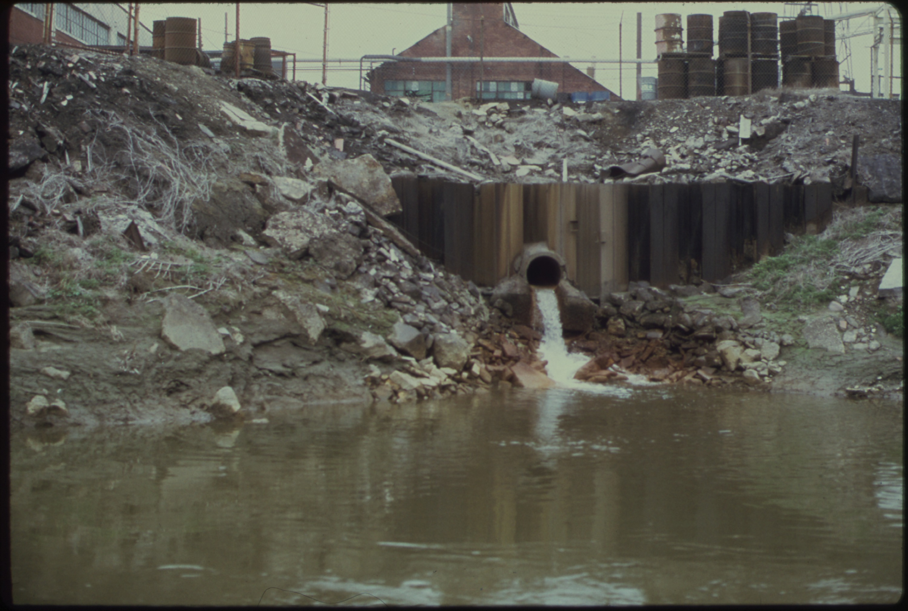


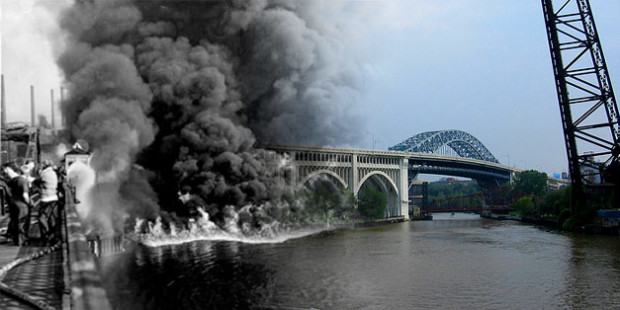


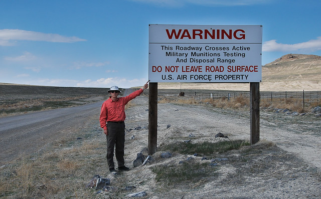


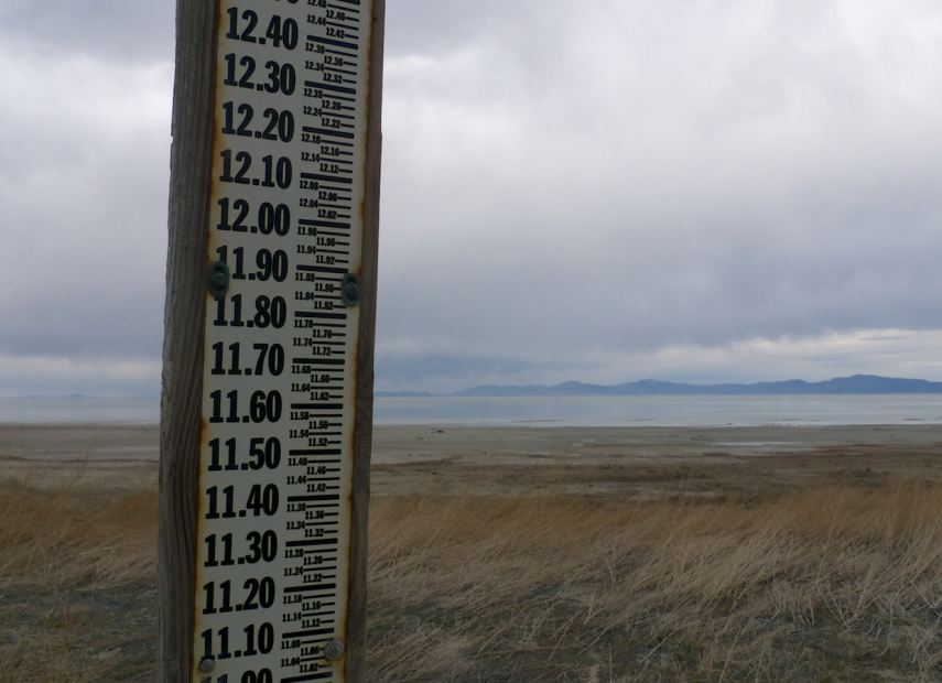
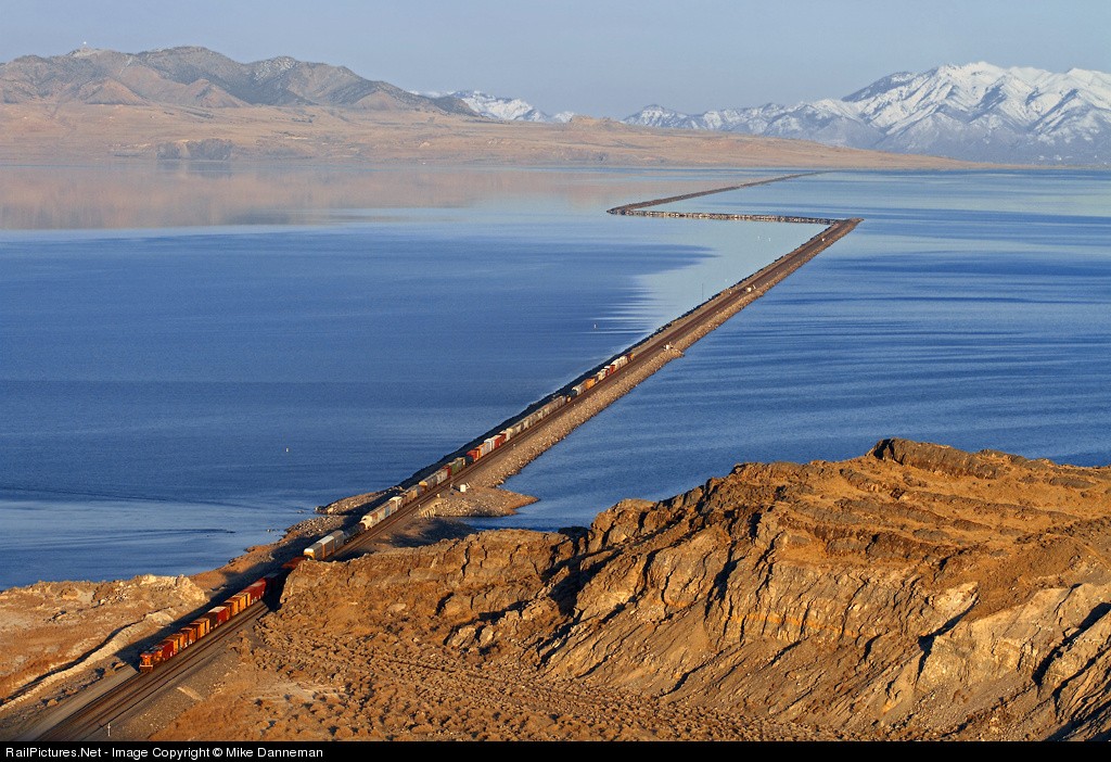
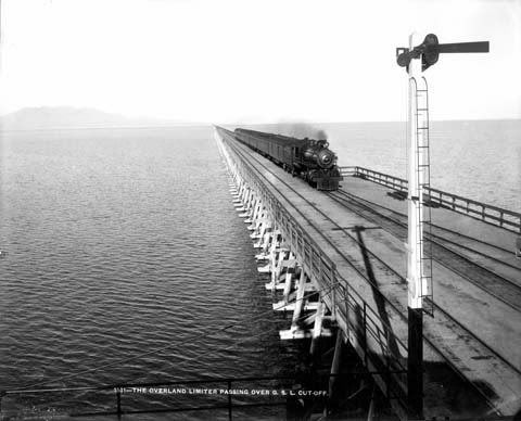
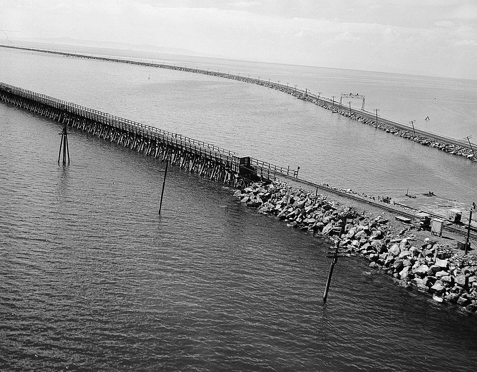

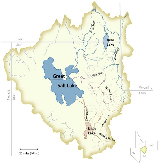
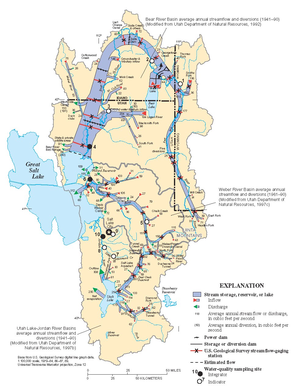
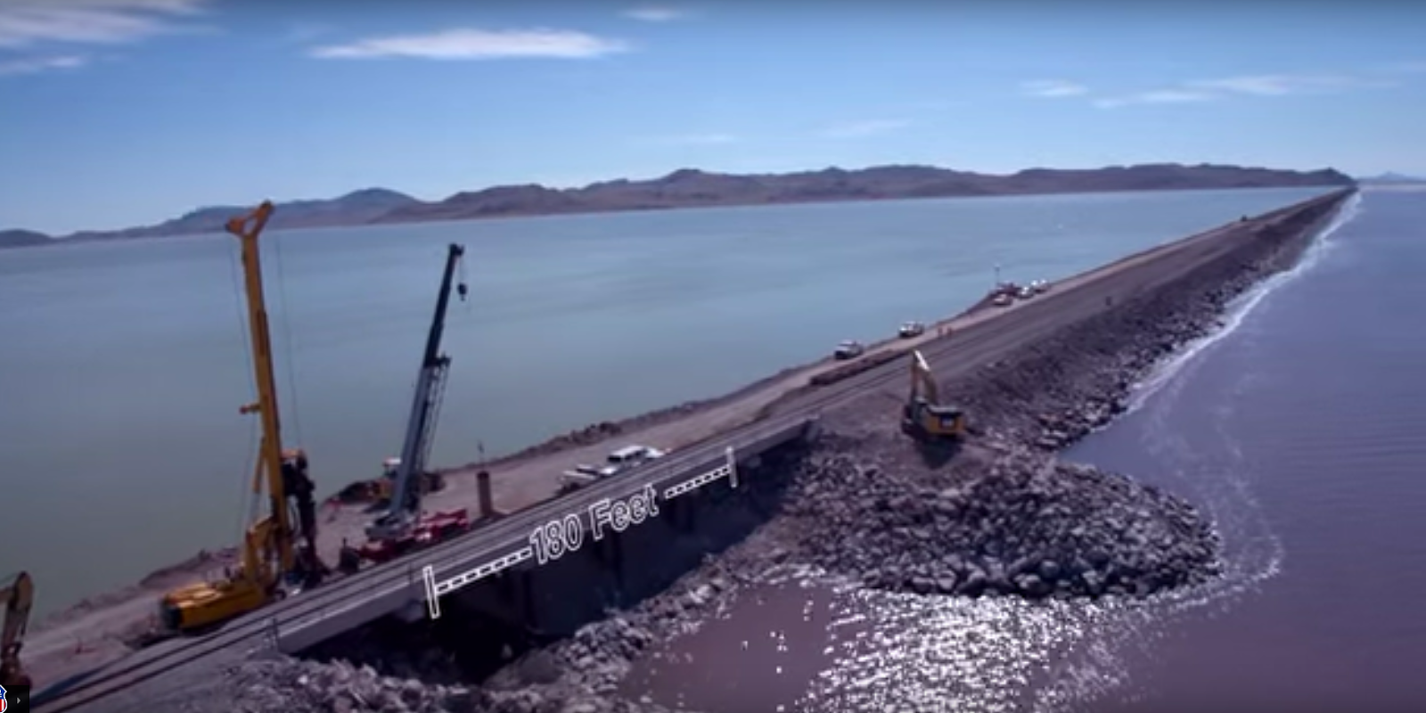

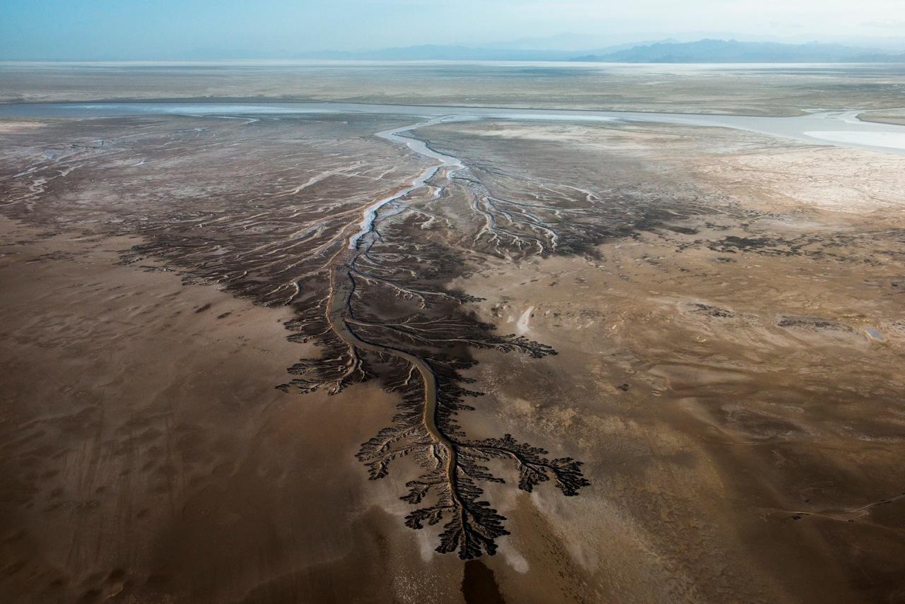
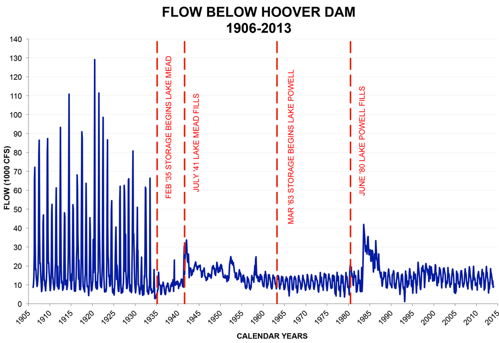


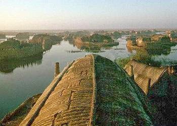


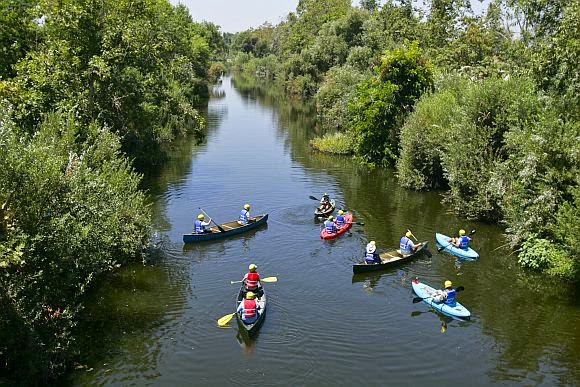


