Categories
Uncategorized

Maps

Again, the issue here appears to be that you can buy maps maybe in Bogota, reams’ of em, but not so much here… although thinking like the locals to some degree means thinking in terms of trails and valleys and rivers, not maps, but I am ready for a good map.

Google Earth
It supplies some good info, but not really useable for navigation. Things are put in the wrong places by armatures (armatures Donny!), and as much as it is fun to play with, the detail is not there. There are also issues with cloud cover in the pictures. The one that streams to PC’s gives you altitude and other helpful things, which is better than the dumbed down version on this IPad.

Falconview.com
I seems to be the best online mapping resource, and looking at it for about one second taught me something I wanted to know about the long valley approaches. It’s a 200 mb download to a PC. I had never heard about it before,but a young Army Officer I met up in the Sierra told me it was what they used, so I might as well also. I downloaded it to the PC in my hotel,but couldn’t get it to work, but from what could tell, this is the gold standard for Internet mapping in Colombia, and perhaps the world. There is no Tablet Version yet for nonmilitary.

Military Maps
Without going into detail, I was given access to a pair of military maps with a lot of info that was fascinating on the security situation, but I would describe the maps as better than average but not good enough to navigate by. The scale on these maps was like 1:100,000 or 200,000, and a centimeter was a kilometer, so as much as it offered a cool overview, it wasn’t good enough to use, say, to get in from the north over open country. But given how you need to rely on local knowledge and you end up following Indigenous foot trails anyhow, it might do in a pinch. I wonder if they have maps on the 1:24,000 or so scale for real operations, and if I could get these… Bogota again would be my guess…
It did however have the name of every river and native settlement of more than maybe 100 people, the best I have seen so far. I was allowed to take pictures of these maps which I will post soon.

The Maps in the Library:
There were two in the back of the Library of the NAtional Bank (literally on the second floor of what is like the Colombian Federal Reserve Branch on Carrera 9 (9th avenue) and Calle 16 (16th St) in Valledupar.
One was a three-dimensional multi colored graphic which highlighted the vertical dimensions of the Sierra from the South West perspective, and another seemed to focus on Indigenous areas, and was mostly brown, and did have some detail.

Categories
Uncategorized

A Review of the Literature

There Seems to be only a handful of Books about the Sierra.
My search so far has been limited to information available on the Internet, and the Library of the National Bank of Colombia here in Valledupar
The library had a handful of mildly useful things, including a few maps that were actually on the wall. There were some books on Natives in Colombia, a few were overviews or surveys with only a page or two dedicated to each of the tribes here in the Sierra. It’s said that Bogota is where everything is, and that finding things like book stores is difficult everywhere else. There are two libraries in Valledupar, and the bigger of the two was randomly closed when I showed up. When I asked the security guard why, implying that it sounded like a corrupt cock up, he kind of smiled that smile that said you’re right, but having grown up in Colombia, I would never say that,but I am kind of excited you said it!

Wikipedia:
it has what it has… the entries in Spanish appear to be a lot more rich in detail.. maybe it’s time for me to take my spanish to the next level, hey babe!
http://en.wikipedia.org/wiki/Sierra_Nevada_de_Santa_Marta

Expeditions:
I have found two, one seems to be translated into spanish from some european langauge, and is account of a guy named Plouffie or something like that who went into the sierra from the Coast along the Palomino it appears in 1916.. it has a lot of discussion of Koguis and Arawakus, much of it anecdotal. My spanish is just barely sufficient for this kind of prose, but I saw a bit on how bug bites had him laid out for a month due to infections in his feet, which rang true for me since the only reason I was in the damn library is because I am limping with a foot infection as we speak.

William Sefriz from the University of Pennsylvania seems to have gone up the mountain from the Caribbean in 1934. I have to work up the courage to shell out the 12 bucks to read his book, and it’s likely worth it, I just hate the drudgery of e commerce! I’ll get it eventually..
http://www.jstor.org/discover/10.2307/208919?uid=3737808&uid=2460338175&uid=2460337935&uid=2129&uid=2&uid=70&uid=4&uid=83&uid=63&sid=21101425144893

Categories
Uncategorized

4 Possible Approaches, Well 5 If You Count Aircraft

As no one has climbed the mountain in 20 years at least, as far as I can tell, due to the two somewhat related issues of FARQ presence and the ‘Sacredness’ issue, the biggest problem in making it to the top of Pico Cristobal Colon is not how to climb it, as that is the fun dilemma of the climbers (although gasping for air about 3/4 up they might beg to differ that there could be any bigger problems in the world), the great dilemma here is the combination of human and geographic influences that make the approach to the likely south side base camp at The 5 Blue Lakes. Here is a list of obvious options I have dreamed up with no input from anyone with experience in the range other than the Military, although the time is coming soon to try to reach some of these people:

1. The Classic Route, from Sea to Summit, along the Don Diego and Palomino watersheds.
2. From Minca
3. The Long Valleys from Guatepuri
4. Over Hill and Dale from Nuagaskimake
5. Flying the friendly skies to the 5 Blue Lakes

Categories
Uncategorized

Approach 2: From Minca

Santa Marta is the Colombian Honolulu, and since this is kind of the beach party town of choice, since Cartagena is more of a kind of Santa Barbera meets Savannah meets South Beach situation, still the domain of the rich, Santa Marta is developing a reputation as the accessible beach town, with Tayrona National PArk it’s Kauai or north shore to explore, Tagonga is it’s backpacker ghetto (dinner there was enough for me..), and Minca it’s mountain outpost, and access point to the Ciudad Perdido, the lost city of the Pre-Colombian Tayrona culture that thrived for a while and was rediscovered in the 70’s, and is now a backpacker pilgrimage, complete with set pit stops and a thriving guiding business. I have not been to Minca, but supposedly you can drive to perhaps even 2000 m by road. This is definitely a safe area from FARC, and has the most foreign presence, therefore might be an easy access above tree line. What I can’t attest to is that you could get to a legitimate base camp for accessing the Pico Cristobol Colon without having to cross some tough ridges head on, which would be logistically difficult to say the least. the Ciudad Perdido, beautiful though it might be, is a 40k walk from Minca, but as far as I can tell,still pretty damn far from the peak as well, and I don’t know that there is any developed trail infrastructure beyond it.. it merits finding out, I just haven’t..
It has been rumored to me that there are guides in Minca who might take you above tree line, but I have been unable to prove this as more than speculation or confusion of trips to the Ciudad Perdido with trips to the High Peaks Area.
Verdict: Inconclusive

Categories
Uncategorized

Approach 1:The Classic Route, Sea to Sierra up the Palomino or Don Diego Rivers

If you were to go the Sourdough way, and decided that the classiest way to approach this dilemma would be to go from the Caribbean Sea, beachside, at 0 feet, up the north side, as climbers are prone to this kind of absolute romanticism, there are two river valleys and a system of trails that might actually work. this would be an exotic endeavor, possibly 5 days in, through the most wild part of the sierra I have seen, both culturally and ecologically. As I went through Messetta on my first excursion, the kid I hired to guide me to the town, since I was miserably lost and stumbled into the ravine he was working in and was spotted by a lady out walking with her kids as undoubtedly out of place, and who proved to be a fun and able guide, even climbing an orange tree as we passed by his house to shake down about 20 oranges for us as I admired the Sierra, told me that from Messetta, about a half day to a day’s walk in, it was 4 more days to the snows, along this muddy trail, an official Camino Real, that we walked on for part of our 1 hour trip, and I followed out to the highway some 8 hours downhill (supposedly I missed s shortcut), and it would go all the way to the last village. So either with backpacks or pack animals, even though you would be passing through at least a handful of Arawaku and Kogui villages, the latter of which might give you issues, it’s possible to make it to the snows from Sea to Summit would be my guess. There is also a waterfall someplace in this area, possibly 200 feet tall. A guide trying to drum up business in Palomino showed me pictures of it, and i think it was called La Cascada Crystal.
The Camino Real, kind of a 5 foot wide unmaintained but certainly passable walking trail, reminiscent to me of the Natchez trace in the American South, was definitely muddy in spots as it was still rainy season, but looked passable for a few days distance at least would be my guess.. it would be a true adventure, but how depleted might a climber be 5 days in. The first half day, especially on the Don Diego, beautiful though it may be, would be in jungle, and through the Don Diegito Canyon (Don Diegito means little Don Diego, -ito meaning little when added to any word in spanish, and the Don Diegito runs off the Don Diego pretty close to sea level and up to Messetta close enough to where you could jump to the Palomino in about an hour if you wanted to, and I believe the Camino Real does this) .. This opens the possibility for all sorts of insect bites and contamination. The jungle would give way to subtropical areas and cleared fields for crops and cattle. I was told that tree line near there would be at about 3800 M, which seemed possible given how warm and humid the air off the Caribbean is. I should just sit down with Google Earth and get that figure for myself.
This would be the classic route, the Mega-Transect of sorts for the Sierra, the undeniable Herculean effort that would make the peak truly sweet. The draw backs are the potential difficulties in Kogui Lands, the steepness of the Mountain from the north, the idea that the base camp and route could be in perpetual shadow during a January Climb, and my lack of knowledge of where a base camp might legitimately be established on that side, although anything is possible. I have yet to recall seeing a lake on that side, although I did see snow, so water would be available, once you made it to the snows, and where there is snow there is runoff, but whether you could follow these rivers is again speculation, especially with pack animals, all the way up to an access point to the mountain. I also must admit, that from where I sat, from about 20 miles away, it was hard to imagine that the rock was that clean. the north side looked like a big black rock slide to me.

Categories
Uncategorized

The 4 Indigenous Groups of the Sierra Nevada de Santa Marta

If you want exotic, if you want indigenous cultures, the Sierra Nevada de Santa Marta has them in spades. I am not talking Indian Casinos and Museaums, I am talking time capsuls, people truly living with the methods of another time, pre enlightenment, with on occasional cell phone thrown in, but it just accents how resilient thier culture has been when it coems flying out of a heavy cloak pocket made of yucca sinew and they start speaking in what sounds like chicken clucks to you. They might keep you from getting to the mountain the way you like, but they sure as heck will intrigue you for a bit, might even charm you as has happened to me with the Arawaku’s and some of the higher elevation Koguis, who are the nuttiest of the bunch as I can tell. I have seen mountainous indigenous people in the Himalayas, and they are charming indeed, and I know them to exists in this form, in their traditional lifestyle, in other parts of the Andes, most notably Bolivia, now Ecuador as I travel, and Peru, and in the Amazon and parts of the frontier region between Venezuela, the Guyanas and Surinam and Brazil, but this is a pretty unadulterated bunch for only 2 and a half hours flight from Miami. I’ll finish the survey by saying that parts of Timor, Indonesia and Papua New Guinea still have indigenous tribes living unadulterated (except for an odd cell phone as usual), as well as areas in Southern Africa, like Namibia and Botswana, and some Eskimo groups up north, but with each passing year the numbers do decline, and about half the languages in the world, 3000 of 6000 are in danger of extinction in the next generation. That is not a fear here, with only one of the four languages of the Sierra Nevada tongues gone, and the other 3 doing quite well.
The tribes in the Sierra come from the Pre-Colombian tribes of the region obviously, and there was a high culture called the Tayrona that seemed to decline sometime in the 1400’s, before Columbus from what I can tell. Their capitol city, now called Ciudad Perdida, Spanish for Lost City, rediscovered in the 1970’s, was over by Minca, above Santa Marta, and as I have mentioned in relationship to security, is now a popular 3-4 day 40 km tourist trek, one I kind of wish I had done, as I poked around the rougher edges of th sierra without a fun kind of hit on the German chick excursion. The tribes in the Sierra either descended from them, or moved into the sierra to escape the movement of the Spanish into the Valleys from their original foot holds on the coast from the beginning of the 1500’s. The Spanish came looking for gold, but eventually moved into agriculture in Colombia as they did all over Latin America. They sent explorations into the interiors, the famed Conquistadors, starting in the 1520’s or so and 1530’s, and started creating towns soon after, although there was a large population of Indigenous already there obviously. The unfortunate fact over all of the Americas is that their numbers were cut usually by 90% by the diseases brought by the Westerners, so that the population densities are higher than assumed by the original writers, perhaps in line with the Sierra today. Valledupar was named after the local chieftain whose settlement might have been there, the same with Mompox. There were other dominant or high cultures in the Magdalena river valley near Mompox, where they undertook to build ditches, dykes for farming, and platforms for living to deal with the inevitable flooding of the cienegas (in this case fresh water swamps and lagoons, although the word can mean salt water ones as well, as with the ones between Santa Marta and Barranquilla) in these areas, and another famous or two tribe south of or near Bogota and one in San Antonio from whence the gold came, often from grave robbing, but these cultures had stone carving and evident contact with the Incas.
Alright,..to the present day.

First a bit of anthropology I guess. The Upper Limit of the Habitation of the Sierra tends to be about 7500 ft, about 2500 meters, because this is the upper extent of Plantain growth in the Sierra, their main staple, according to something I read. This jibes with what I saw. The valleys also seemed to be open well below an alleged tree line of 11,000 ft in spots, down to like 6000 ft above Guatapuri, and I chalk this up to perhaps grazing, lack of sunlight in spots due to the steepness and the east west running ridges, or just me not having the eyes to distinguish trees from where I stood.

These are the 4 tribes of the Sierra
Kogui

Arawaku

Wiwas
Kancuamos

there is a kind of fifth tribe, the Hippie Koguis, made up of Urban Refugees from both Colombia and outside. They are also referred to as the ‘Civilizados’, the civilized ones. I probed if this was considered an inapropriate term by the natives, but some Arawakus made it plain they didn’t give a crap. the Arawakus have a lot of pride!They seem to ahve come in the 70’s, kind of Vermont for the Guerilla resistant, and live amongst the natives in little farms kind of doing their own thing. Some of them serve as Paramedics for the tribes in a program they call Medicos. They number below 100 I was told. I met perhaps 5, in a kind of magical surreal run in with civilization worthy of a scene from Apocolypse Now, and heard of another, an America, who built a piece of Paradise above Guatapuri, but hustled out ahead of the FARC, his house now in ruins but with a row of trees still marking how to get there.

nearby, the Wayuu’s of La Guajira and

Embrerra of The Darian Region and Choco

The Crazy tribe that likes to drink across the valley whose name now escapes me, but they live along the Venezuelan border and are known for being pretty feral drunks.. everyone describes them the way Europeans might descibe the Irish, with a kind of wistful respect.
Categories
Uncategorized

The Obvious Basecamp

the Five Blue Lakes

I don’t know much about them, but they sit to the south of the two main peaks, offering water, meditation, and some flat territory I believe. I have seen photos I think depict them, and I think they do get substantial sun from the south since they are on a high plateau, perhaps at 12,000 feet. That altitude at this latitude actually allows for bushes and plant life beyond lichens and moss. In most of the Andes it is called Paramo, and I would assume it to be the same here, although some photos I look at make it look like slick rock or boulder fields, or craggy rock as well.

http://en.wikipedia.org/wiki/P%C3%A1ramo

It would be my guess that the Five Blue Lakes are the logical base camp for an ascent. Part of me has been working in secrecy, but the best way to prove this would be to reach out to one of the people who climbed in the Sierra before it got two dangerous. I have found once such person online, but the email I sent didn’t come back.

Categories
Uncategorized

Approach 5: The Aviation Option

I have been living in Talkeetna just long enough to not realize there are any other wyas to get up a mountain. In The Alaska Range, you fly in, simple as that. There was an occasional NOLS trip up the Muldrow Glacier of Denali each year in commemoration of the Sourdoughs. I have also had people I know hike into or out of the Alaska Range. I once passed an AMS truck picking people up who walked out of the range. The buddies I had walk in regretted it, got beat up by bugs and musqueg, and the guys I saw driving out past Petersville having descended more or less the Kahiltna Glacier seemed tired as could be but nonetheless proud. Marsh and mosquitos are the issue in Alaska. Down here I would guess it is Jungle, possible disease and infection, the dramatic variations in climate that would get you whacky, and just saving yourself health wise for what is to come.
There are no charter aviation assets in Valledupar airport. I just tried to find some. Daily flights from one terminal to like Bogota and Barranquilla, maybe a few other spots, and that’s about it. Not another Hanger on the Runway.
They used to Helicopter people into Ciudad Perdido, but the park banned it as too disruptive. The army can medevac tourists out from there I have heard in a pinch.
Barranquilla and Santa Marta both must have a nice airport, and in fact, Barranquilla airport was the first one in South America, and the birthplace of Avianca Airlines. It merits a look.
the last option is the Military.. would appealing to national pride free up a lift in a black hawk to maybe 12k feet.. something to wonder. They got one parked over at the Battalion right now..

Categories
Uncategorized

The Ideal Season

Northern Colombia has mas ou menos 2 seasons, Dry and Wet, which they call Summer and Winter. There is still a daily cloud cycle, at least from the south, but Winter seems to last from March or so to December, although I have also heard it described as September to December. Colombia has a funny immunity to Hurricanes, as they rarely ever turn south as they move across the Caribbean, the trade winds I guess always taking them north until they link up with the Northern Jet Stream and dissipate. I guess nothing is impossible, but thereis no discussion of any large storms hitting the country in anything I have seen, despite it being relatively close to the bowling alley that is Central America.
I arrived in Cartegena after Thanksgiving in the US, late November, and there were a few days of overcast and rain. as I moved west from Cartagena to Brranquilla, the first place where I might have been able to catch a glimpse of the sierra, sometime in early to mid December, the thing was clouded over ever time I tried to look, but someone told me in pasing I had to wake up early, but either it was my decadent lifestyle or the mountain playing shy due to season because I never caught a glimpse. The Endof the Magdellena River Valley, the Mississippi or Nile of Colombia, never shwoed me a horizon. By the time I got to Santa Masta as Christmas approached, there was no doubt there was a mountain there because from the time you hit Cianaga by the Grand Marsh you are driving along it’s flanks like some of the highways of Hawaii, and there was no avoiding the notion that it was there but the diurial variations seemed to prefer morning for a clear view.
From Santa Marta I don’t think the peak was visible, but there were clear days there on the coast that didn’t necessarily translate every day to clarity in the mountains, but you seemed to be able to see pretty high, if not to the snows. while in Palomino just before christmas there was a lot of change from cloudy to clear, both daily and I think front wise, and once a storm came through with some pretty tremendous power. My first incursion into the sierra, three days that had me go from Palomino up the Trail that parallels but does not completely follow the Rio Palomino to a Kogui town known as La Culebra but also a Kogui name of _____, over the river to an Arawaku town called Messetta, and down the Don Diego, I was moving along at what must have been 8am towards Messetta over some neighborhood trails indicated to me by a local Klan head, when I caught my first clear in all it’s glory sight of the Sierra,with not a cloud to encumber from the north. Around Christmas Day in Riohacha I waited every day to catch a glimpse, waking early on occasion, from a beach front hotel with a dominant view,but it still played shy, and more rain came, but finally, at some point, the haze and clouds seemed to lift,andit decided to come out and stay out almost every day. It became windy,and as I moved to valledupar, this kind of held up, dry windy, and clear, to the point where I started to feel like I was in the Valley around Bishop California looking up at Mount Whitney from the back side. There seem to be a palce or two where the Mountain was visible between Maicao and Valledupar, but for the most part the lower peaks, all 3-4000m obscure it, but from essentially Christmas on I had visibility with a daily clouding up around noon then dissipating. It is possible that the high peaks region remains above this daily clouding. the ceiling I observed once to be around 8000 ft, and it never dropped down to 6000 was I was sitting near San Jose, jsut lifted and broke up around nightfall.
It would be my speculation that Early January would be the sweet spot for climbing, in a normal season. Global Climate Change has turned absurd the notion of “As Regular as the Weather”. Research would indicate what effect El Niño and La Niña might have on the Sierra, but I haven’t stumbled onto anything akin to a Colombian NOAA (although I shouldn’t rule it out). Another Benefit to January is that the sun is close to being at it’s furthest away. The sun moves back and fourth across the globe at a speed I once calclated to be about 15 Miles per Day, 25 kilometers, which is about 1/4 of a latitude line a day. It’s roasting northern Chile about this time, which is as far away as it will ever get. This keeps the back side of the mountain actually in shadows until I would have to guess until about may, at which point the shadows, if any as the sun would be almost directly overhead, would be on the south side until maybe late july when it would pass directly overhead again, but I would ahve to imagine that is a rough time to be up there. Also, the snow would likely be freshest and firmest at this time for both water use and climbing, as well as the ice.Asnothing is certain at this time, the mountains of the Sierra Oriental near Buccaramanga are predicted to loose their snow in 15 years.. might be time to bottle up whats left on the Santa Marta, mightbe worth something!
It’s Mid January 2013 now, and forest fires are becoming an issue. The newspapers are indicating this is an unusually dry year, and the rio Magdalena is running as low as ever (as is the Mississippi back home just to add). As if to remind me, as I have been typing this in the lengthening sunset, I noticed one on one of the foothills just north of Valledupar as I write near my hotel room window. It adds an exotic touch, as from what must be three miles away I can clearly see a line of flame. I watched one from Nagusimake as well in early January and that night it had an impact on my throat as I slept,and another above Guatepuri my first night there. It made me feel as if I was on the edge of the Heart of Darkness, in the night as I discussed battles that had taken place where I was standing between the FARQ, the paramilitaries and the Ejercisios in the dark with my accidental host, a local guy with a young family who had lived through it. I was told it had been set by Koguis for slash and burn. In the high peaks area I would imagine this to not be an issue. On my last excursion, the aformentioned to Guatepuri, I was at about 6000 ft above San Jose and I realized the air was as clean as I had noticed in Colombia, and clear of the ever present wood smoke of the indigenous villages as well. It would have to be one hell of a fire to cloud up the whole sierra, but anything is possible these days.

Categories
Uncategorized

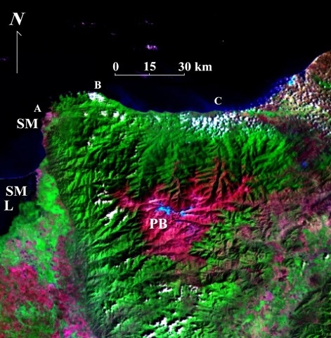
An infrared photo of the Sierra (I think.. something like that)

This displays reflectivity which shows you ground cover, from ocean to jungle to grass to rock to snow, moving from bottom to top.

20130114-122419.jpg